Piusa’s sandstone tunnels are one of South-Eastern Estonia’s most striking natural heritage sites-shaped by decades of glass-sand mining and now protected for their unique bat-friendly microclimate. Since the caves have been closed to the public due to collapse risk, experiencing this underground world has long been limited to stories and photographs. This project changes that by delivering a 3D model of Piusa Caves that captures the scale, textures, and atmosphere of the tunnels in high detail, allowing visitors to explore the cave system virtually and safely through an interactive application.
The Piusa Sandstone Caves
Between 1922 and 1966, miners extracted glass sand in Piusa and created an extensive underground network of sandstone pillars and vaulted chambers. The tunnel system extends for approximately 20 kilometres, and the unique environmental conditions have made the Piusa caves the largest hibernation site for bats in the Baltic region. For this reason, the area is under nature protection.
The caves once welcomed visitors, but authorities permanently closed them to the public in 2006 because of a collapse risk. Despite this, the Piusa Visitor Centre has become one of the most popular tourist attractions in South-Eastern Estonia.
Modern technology has made it possible to bring this heritage closer to visitors once again. In cooperation with the Piusa Visitor Centre, Võrumaa Development Centre, Võru Municipality, Maperions, and the Estonia–Latvia Interreg programme, a project was launched with the goal of creating an accurate 3D model of approximately 1.2 km² of the Piusa cave system. Through a dedicated application, visitors can now explore the caves virtually.
Our experienced 3D Wayfinder team completed the work. We had previously mapped smaller cave sections with laser scanning. This time, we captured the entire cave system with a different methodology.
Choosing Photogrammetry
The aim was to create a model that was as precise and detailed as possible. After careful evaluation, we chose photogrammetry as the most suitable method for mapping such a large, complex environment. Photogrammetry enables the creation of 3D models from a large number of aligned images and offers high accuracy, while also capturing the natural colours and textures of the caves.
We used dedicated software to align images and generate the model. For this project, we used the professional version of Agisoft Metashape, which also supports 360° panoramic images. However, achieving reliable results required overcoming several challenges—the first being proper lighting conditions.
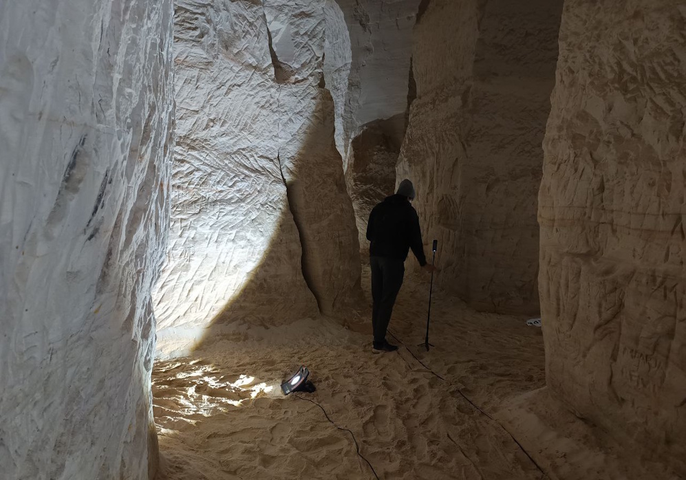
Photogrammetry requires uniform, diffused lighting that remains consistent throughout the entire capture process. Naturally, such conditions do not exist in caves. To solve this, the Wayfinder team divided the cave into manageable sections using hand-drawn sketches and historical cave maps. Each section was photographed individually, illuminating only one area at a time.
Power was supplied via one fixed electrical outlet, two large battery stations, and approximately 20 construction lights.
Image Capture Workflow
With the section-by-section lighting approach, we photographed the entire cave system using an Insta360 camera on a tripod. We followed a systematic workflow. After installing lighting for a section, the team moved along a pre-planned route, positioned the camera, and captured three images using Automatic Exposure Bracketing (AEB) through a connected mobile app. This produced highly detailed DNG files suitable for further processing.
Because we had to trigger the camera near its position, we had only 5–10 seconds to move out of sight behind a pillar after starting the capture. Each AEB sequence took approximately 15 seconds. Once the app confirmed that the images were taken, the camera was moved forward by roughly 1.5 metres, the position was marked on a sketch, and the process was repeated. During breaks, we checked memory capacity and battery levels.
Using 360° images reduces the number of images needed and allows capture from a single height. Under the given conditions, this proved to be the most efficient approach. Under these conditions, the team found this approach the most efficient. In total, they captured about 1,200 images. The lighting and photography process took 52 hours in the cool, humid cave environment, a challenge the Wayfinder team embraced without hesitation.
Model Creation
High-quality images are essential for creating a high-quality model, but the next major challenge was preparing this large dataset for processing. For each capture position, we merged the three AEB images into one image. We also colour-balanced the result to keep each section consistent.
Model creation was carried out in Agisoft Metashape. Images were organised by area and processed section by section, combining multiple sections where possible to achieve a more cohesive result. In total, the cave model consisted of 16 sections. Each section went through the following stages: image alignment, point cloud generation, and 3D mesh creation.
Due to challenging lighting conditions, the initial models were not perfectly clean. Therefore, the meshes were exported to external 3D software for manual cleanup, correction, and geometry optimisation. It was crucial to maintain the exact coordinate alignment used in Agisoft, as all image alignment was based on this coordinate system. After refinement, we imported the models back into Agisoft. Then generated textures from the aligned images to match the real cave environment as closely as possible.
After all 16 sections were completed, they were carefully assembled into a single coherent model. Using working sketches and distinctive cave features as references, overlapping areas were trimmed where better results existed in other sections. These aligned, textured sections formed the basis for all subsequent steps.
Final Model and Virtual Experience
The Agisoft models delivered high detail, but they also produced extremely large files. Each section ranged from 80 to 250 MB in size, while the final application required the entire cave model—including textures—to remain around 100 MB for optimal performance. This meant reducing the data size by approximately 90% without compromising visual quality.
We achieved this by transferring high-polygon detail onto a low-polygon model using normal maps. First, we merged all sections into one high-detail model. Then created an optimised low-polygon version and added UV mapping. Normal map baking and texture transfer preserved the appearance of the high-detail model while dramatically reducing file size.
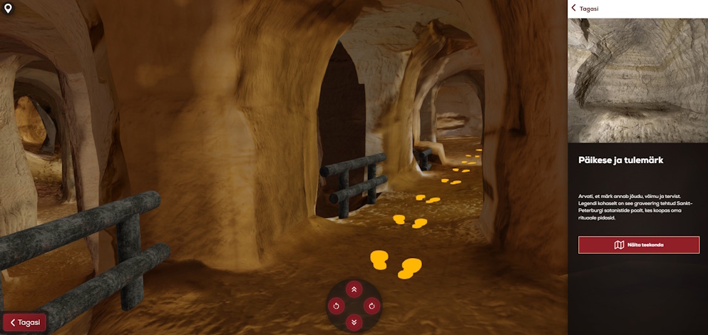
We deployed the final model on the 3D Wayfinder platform. We added navigable paths, a user interface, and animated bats. Visitors can now safely explore the otherwise inaccessible cave system on a large interactive screen, experiencing a unique natural heritage site through virtual technology.
You can read a more detailed and technical introduction to our modeling here.