In our fast-paced world, efficient and reliable public transportation is essential for the daily commute of millions. Whether it’s the bustling metropolis or a smaller town. However the need for accurate and up-to-date transportation information cannot be overstated. One significant development in this regard is the introduction of digital public transportation schedules integrated to 3D Wayfinder software.
Gone are the days of deciphering cryptic timetables and struggling with maps. Because modern technology is transforming how we access and interact with public transportation information. Besides wayfinding, visitors of malls and other public buildings would like to see how to get to bus or train. Also when will the bus, train or other transportation vehicle departure.
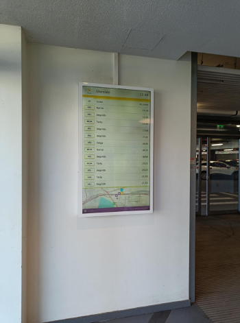
We have developed special module for 3D Wayfinder software to show public transportation schedules. These schedules are optimize for public screens. And these can work with touchscreens or just LCD screens and can be in any resolution and size. In other hand touchscreens provide more features as schedules can be scroll or filter, but can be use as well on regular screens. In this case we will filter transportation schedules by time and switch between modes automatically. Similar to screens of arrivals and departures in airports.
Transportation schedules may be part of wayfinding software. For example visitors can be guided to right bus- or train stop or they can be used on separate screens. We are supporting transportation schedule standards, so for most countries it would be easy to integrate to get the schedules working.
Real time updates
One of the most significant advantages of digital transportation schedules is their ability to provide real-time updates. Gone are the days of relying on static paper schedules that may not reflect sudden delays or changes in services. With digital displays, computers can access live information about their transportation options, ensuring they are always in the know. It is even possible to visualize busses or trains on wayfinding map. With 3D Wayfinder, the vehicles can be 3D models and with billboards we can even show the destination of specific train.
Accessibility for All
Digital public transportation schedules are designed to be accessible to everyone, including individuals with disabilities. With our wayfinding software, we have set the accessibility as one of the top priorities. The same is with transportation schedules. Public buildings are increasingly incorporating features like large fonts, clear visual elements, and even audio announcements for the visually impaired. This ensures that transportation information is available to everyone, promoting inclusivity and independence in the daily lives of all citizens.
Reduced Environmental Impact
Digital displays significantly reduce the environmental impact of public transportation schedules. The production of paper schedules and their disposal can contribute to deforestation and waste. Also which can be minimized with the use of digital alternatives. Furthermore, cutting down on paper usage aligns with sustainability goals and reduces carbon footprints. Besides that, public transportation is always greener than using cars. Therefore making public transportation convenient to use makes people also prefer public transportation.
Intermodal Connectivity
Many public buildings now offer integrated digital information hubs that provide not only bus and train schedules but also information on other forms of transportation like bike-sharing services and ride-sharing options. This holistic approach to transit information allows commuters to make informed choices about their journey and to combine different modes of transportation seamlessly.
Interactive Maps
Digital displays often come equipped with interactive maps that help commuters plan their journeys more effectively. These maps can display routes, stops, and connections, making it easier for travelers to navigate unfamiliar public transportation systems. Integrating bus schedules into wayfinding software, makes it easy for visitors to see, how to plan their trips inside malls and other large buildings.
Paper schedules can be a breeding ground for confusion, especially when multiple services share the same timetable or when there are frequent service updates. Digital schedules minimize this confusion by clearly displaying the relevant information in an easy-to-understand format. We are using maps provided by OpenStreetMap to show the transportation routes. So it would be easy to understand where you have to go, and what bus or train route you should take.
Cost Savings
While the initial investment in digital displays may be larger than printed posters, the long-term cost savings are substantial. Digital screens can show advertisements while on idle mode or between the transportation schedules. 3D Wayfinder advertisement module is able to define different frames and even split the screen between different application. This means that digital screens earn back the investment pretty quickly. Maintenance and updates are often less expensive than printing and distributing paper schedules, making it a sound financial decision for public transportation providers.
The integration of digital public transportation schedules in public buildings is undoubtedly a game-changer for both commuters and transit authorities. The benefits of real-time updates, accessibility for all, reduced environmental impact, intermodal connectivity, interactive maps, reduced confusion, and cost savings make it a worthwhile investment in our urban infrastructure. It would be good add-on to your wayfinding application, especially in buildings that are transportation hubs.
If you like to know more about our public transportation schedules integrated to 3D Wayfinder software, please contact sales.