How 3D Wayfinder Software Makes Hospitals Better

April 25, 2022

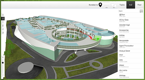
3D Wayfinder R&D AS has successfully completed as many as 200 projects a round the world. Below map gives you just small glimpse where you can find our work. Find out how hospital wayfinding software works.

3D Wayfinder R&D project map for wayfinding software projects globally.
3D Wayfinder global projects

Opportunity to work with clients globally has been beneficial to us all. Making our team stronger in 3D wayfinding software development and helping our clients to conquer their challenges. From the knowledge we have gathered we have now good insight what direction wayfinder software can grow in future.

Today, we see rising demand for solutions in healthcare sector. Larger city hospitals have grown to huge building complexes and provide rooms for hundreds of patients at a time. Some medical services are provided in one building and other services in different building. Patients who are staying short time and patients from rural areas are the first ones to discover these difficulties. Finding right cabinet from that maze can be long and challenging event.

How are we going to improve healthcare through wayfinding?

For hospitals we have taken already steps to improve our 3D wayfinder software. “3D Hospital Wayfinder and Management System” has been supported by Estonian-Norway joint-programme Norway Grants “Green ICT programme”. Project timeline is August 2020 till July 2023. Project’s focus is on developing web-based software service for healthcare operations, example hospitals. Like facility’s floor-plan visualization in 3D with universal API for collecting different real-time data and showing it in 3D floor-plans.

More details you can find HERE.

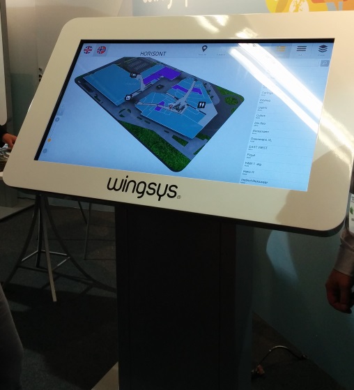
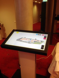
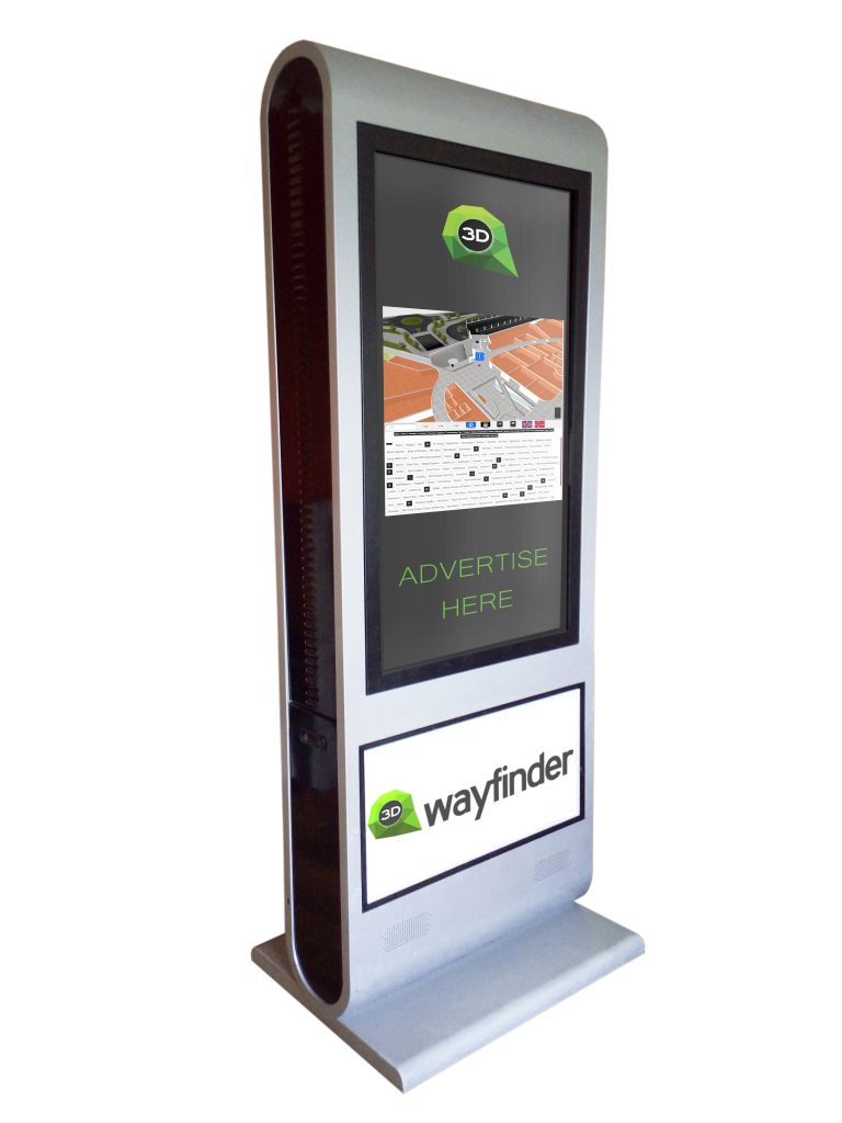
Hospital wayfinding software example

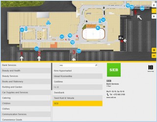
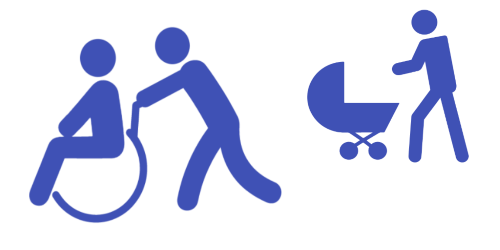
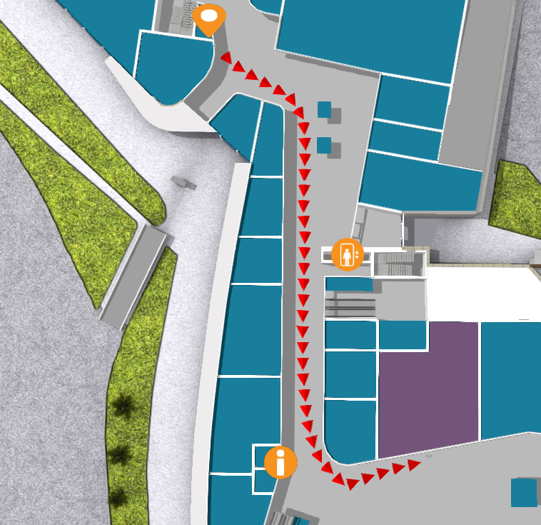
Our project in Poland is a great example how large hospitals can really be. As you can see below picture it is not an easy task to find right location there. The use of the stairs is not possible for a person in a wheelchair. To tackle this issue we have created opportunity to use multiple direction routes.

UCK hospital project in Poland with 3D Wayfinding R&D AS software.

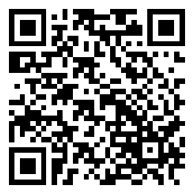
We can’t forget that there are people who do not want to touch kiosks for health reasons or are located in different part of hospital, where there is no self-service kiosks. To tackle this issue we have created QR code based wayfinder solution. Scan QR code with your smartphone and use your device like kiosk. All the functions you get from large self-service kiosk you get in your smart device.

If you have more questions about the software we are happy to talk!

Contact us here!

« »

New Top View Feature in Our Editor

January 2, 2018

Sometimes it’s the small things that make all the difference. New “Toggle top view” feature in 3D Wayfinders administration panels editor is a useful tool that will give needed help to our users.

Toggle top view shows all the maps straight from the top and it works with both 2D and 3D maps. While this feature is selected, the rotation is disabled. This is most useful when marking paths on the map. It could also be used if you want to set kiosk view straight from the top on 3D maps.

New feature in editor

“Toggle top view” can be found on the top of the editor under “Settings“.

« »

3D Model Converting Problems Partially Fixed

November 8, 2017

In recent days, we were having problems with 3D model converter. These problems are partially fixed now, so converting non-corrupted 3D files shouldn’t cause any interruption anymore.

3D Wayfinder’s model file converter has stopped quite often lately, when converting corrupted 3D floor-plan files. Every time converter stopped, we had to start the process manually and clean the converting queue.
All 3D files are converted to JSON format, so they can be load in 3D Wayfinder. Our converter supports many 3D file formats, most common are FBX and DAE.
The problems were with couple of models, that caused invalid JSON when converting.
We have added error catching for this, so the rest of the converting process can resume and these corrupted models don’t interrupt other 3D models to be converted.
If converting of 3D floorplan model fails, you’ll get “ERROR” response in 3D Wayfinder Administration:

3D_model_converting_error

Other reasons, that 3D files couldn’t be converted are mainly caused by using non-UTF characters in mesh names.

« »

Wayfinder With Digital Signage Software

November 2, 2017

We have tested 3D Wayfinder integration with Digitalsignage.com software. Integrating wayfinding with digital signage media management gives additional purpose for advertising screens.

DigitalSignage.com is created by MediaSignage Inc. It is free digital signage software. Including signage player and media content management. Their software is used in over 200 countries. Since the first release, the software has been installed on hundreds of thousands of PCs.

DigitalSignage.com software is web-based. So it is really easy to use 3D Wayfinder as a part of the media player screen layout. Let’s say, that there are top and bottom advertisement banners on the portrait screen and wayfinding application is set-up on the middle of screen.

Wayfinder kiosk

Screensaver mode

More advanced integration is switching advertisements with wayfinding application. This is something, we call “screensaver mode” when creating layouts for 3D Wayfinder. With Digital Signage software the simple way is to switch between wayfinding and advertising screen. Digital signage itself lets you create switching timelines, channels and content. We do not go into that much. Because there are plenty of examples in their documentation.

More sophisticated way to change between 2D map and screensaver can accomplish with event and triggers. Under Digitalsignage.com documentation http://docs.digitalsignage.com/ look for remote values. It describes what should be include in your app to be able to send event to their server.

Two functions that are important in 3D Wayfinder events case are ‘onSessionStart’ and ‘onSessionEnd’. They both are used by our statistics module. But if you do not have any need for statistics then you could overwrite these functions.

With signage free version you can use our 2D map with ease. Just include HTML component into your campaign and add link to your project.

digital signage

From documentation we could find out that signage players HTML component does not support webgl. But according to docs we should be able to get out 3D maps working with Browser component and signage player should be working on windows machine. Browser component is available for enterprise users.

« »

New Features in 3D Wayfinder

January 15, 2016

With the end of 2015 and the beginning of this year there are many new features added to 3D Wayfinder. The goal of these changes was to add flexibility to customizing the behavior of the 3D map and wayfinding. Custom models for path, path types, POI options and many more.

In parallel with large customer projects, we have added many new features to 3D Wayfinder. Most of them were requested by our customers and we have added them as features/settings for all our users. Below are listed the most important ones.

Custom models for path visualizationcustom_path_models_wayfinding

It is now possible to choose your own custom models for path visualization. Path models can be different kind of arrows, footprints or simple tubes/lines. Changing path visualization models can be done under settings.

In near future we’ll add some sample path models also to our blog.

Path types and accessibility paths

It is now possible to add different kind of inaccessibility attributes to the path . This can be used for defining paths  that are also accessible with wheelchairs and/or baby strollers. This also enables defining other kinds of areas, like paths for service personnel etc.

Currently it has to be entered to the node attributes in json object format:

{

“inaccessibility”: [

 “wheelchair”

]

}

wheelchair_wayfinding_inaccessibility_Path_types_and_accessibility_paths

The nodes with these kind of restrictions cannot be used for path finding with “wheelchair” option. It is useful to set these restrictions for stairs or doors.

To use the inaccessibility in user interface, you have to change the accessibility option first:

this.wayfinder.accessibility = “wheelchair”;

Then it is possible to use the same show path method:

this.wayfinder.showPath(poi.node, poi);

And after showing path, just change the accessibility option back to blank:

this.wayfinder.accessibility = “”;

Also check out our blog post about how to set up time dependent navigation rules.

POI specific options

Advanced_POI_settings_specific_options

It is now possible to create special settings for each POI (location). These settings can be chosen from the list of all POI settings, like the size of the billboard image or billboard text size, highlight color, activation radius, billboard height etc.

This feature allows to customize the map by locations, for examples larger shops can have larger texts or text colors can be set by each shop. Also it makes easier to use logos or icons on the map, as the billboard images don’t have to be the same size anymore.

In the future it is possible to add new settings that can be used when developing your own template.

Top-down view for Path showing

path-top-down-view-for-path-showing

Now there is a simple option under settings to turn the map to top-down view when showing the path.

In general it is not a good idea to show the “You are here” location from top-down view, but rather  from certain angle (especially when it is possible with real 3D models as in 3D Wayfinder), which provides a better overview of the map and also makes the map look better.

Now when using the same angle, as displaying the “You are here” location, and visualizing the path, it may happen that the visualized path might not be visible. This is due to tall objects like walls that might block the view of the path. Using the top-down view during path visualization solves this problem.

Pause options between changing floors

According to valuable customer feedback, the transition of switching floors happens too quickly , which might be a bit confusing for the end-users. We solved this issue by adding the “pause-time” option to the settings. With this option it is possible to adjust the duration of the pause before switching to the next floor. The pause duration can be defined in seconds,  which makes it easiest to find  the proper delay that helps  all wayfinder users to understand, which floor they have to go to.

Kiosk view enhancements

In addition to being able to save the view angle, it is now possible to save the zoom factor for “kiosk view”. By clicking the “You are here” button, the map assumes the “kiosk view” saved in the editor.

In the future we will add this view option as a separate object so the view can be linked with any location or node.

« »

Towards Rule-Base Wayfinding

September 25, 2015

Future in wayfinding includes definitely possibility to create complex rules for path finding. Now there are also node restrictions in 3D Wayfinder to specify working days etc.

One of the last addition to 3D Wayfinder was node weights for calculating optimal paths. This made possible to guide visitors in some recommended way. Now there is also possible to restrict some nodes based on time and day.node_restrictions_wayfinding_paths_by_date_and_time

In many public buildings, there are rules for locking doors, elevators or gates. There can be different areas open during working hours than weekends or night times. This is common for shopping malls, train stations, university campuses etc. Even large office buildings are keeping some doors open during the weekends as there might be service providers like dentists, children playrooms etc. When providing wayfinding to your visitors, it is important to follow the same rules.

With 3D Wayfinder, it is possible now to create path restrictions according to work-day and time. To create this kind of restrictions, just open node attributes under editor.
Under Node attributes in 3D Wayfinder Editor, there can be entered JSON. In future we will provide also special UI for that.

Here is the example that will allow to pass the navigation node from 10AM to wayfinding_paths_restriction_node_attributes9PM:

{
“allowedTimes”: [
[
10,
21
]
]
}

Adding other blocks, you can also specify by days.

We are currently developing also other rule types, like security or accessibility. These rules help to create adaptable and user-friendly way-finding applications which are useful and finally elementary for large buildings.

« »

3D Technologies R&D has Launched 3D Floor Plan Application Development Kit

April 4, 2014

We are pleased to announce that 3D Technologies R&D has launched a service for software developers to visualize and interact with 3D floor plans. For example users can create Wayfinding, Smart House and Architecture visualization solutions. Using 3D Wayfinder floor plan application will save development time and gives users out of the box floor plan. The solution runs on touch-screen kiosks, mobile devices and websites, which makes it well scalable.

3D floor plan example

There are many areas where indoor wayfinding solution is useful and even unavoidable, such as shopping centres, transportation stations, sports facilities, hospitals, university campuses, etc. All of these facilities have different kinds of integration needs. This service enables developers to focus on these needs and not to waste time on additional development.

3D Wayfinder takes advantage of the possibilities offered by HTML5 and WebGL, that work on all modern web browsers. Taavi Juursalu, the company’s CTO says: „Our JavaScript API enables developers to intersect and send map specific events, so customizing the map is as easy as the Google Maps API. “

The platform is currently in beta version and therefore free of charge. The company’s Sales and Marketing Manager Rainer Saar adds: „3D Wayfinder for Developers is one of a kind tool in the World today that helps to widen Digital Signage and indoor wayfinding possibilities. Our service enables any developer to start creating applications without the need for specific skills in 3D field“.

3D Technologies R&D is also offering a full wayfinding solution with 3D floor plans and customer specific software development service. Today, 3DWayfinder helps to find the way in many shopping malls and transportation hubs across the World.

« »

October 2013 Newsletter

October 4, 2013

We are pleased to announce that we have made ​​significant progress in the development of a WebGL version of 3D Wayfinder. We are planning to implement it in Atrium shopping center in Russia. WebGL and the power of HTML5 gives new cool designing opportunities for upcoming projects.

Our partner, Akzia Apps has created a super-awesome design. In the near future we will offer You this exclusive chance to be one of the first who gets a glimpse of this cool project. We plan to create all our future projects in WebGL to provide better user experience.

3D Wayfinder does not mean 3-dimensional buidling directory

The whole 3D Technologies R&D team is putting a lot of energy into product development to provide better navigation (wayfinding) for our existing and future partners. We are devoting a lot of time into innovating and testing new solutions. Our team is convinced that the best solutions grow out from engaging in dialogue with users of our products.

Our latest customer surveys revealed that there is also a market for more simpler version of 3D Wayfinder for smaller buildings with smaller budgets. We already receive requests for such solutions and hopefully first one will realize soon.

2Dmap-LK

Maximize ROI

Advertising on smartphones and tablets has shown rising trends in the world and it is becoming more important information channel. 3D Wayfinder is an excellent channel for advertising to reach all user groups. It enables to advertise on all three platforms kiosk, mobile and web, which makes the solution an effective e-commerce channel.

Mobile & Web version

To meet the needs of our customers we have launched a mobile version for Android and iOS users. Windows Phone users can expect the mobile app soon. It has all the basic functions – search, deals, map etc. The building map is 2D so it could work smoothly and simply on most smartphones and tablets. The map is converted from 3D to 2D, to preserve its preciseness and to automate the process of updating. Exactly the same content that is in the kiosk and web version. All managed from one CMS. Mobile offer even more possibilities to integrate different custom solutions like social networks, loyal customer schemes, timetables and other useful features.

You can download the mobile app from your app store by searching “Lounakeskus” or, simply just scan the QR code below.

qrcode_256

If you wish to see the web directory in action then visit Lõunakeskus website (South Center).

We would appreciate any feedback, so if You have any questions, recommendations or desire for cooperation, just let us know.

« »