Exclusive Buildings Need Premium Wayfinder Solutions

October 31, 2022

In the previous post, we introduced different styles of modeling and designing 3D Wayfinder maps. It is clear that exclusive buildings need a premium wayfinder solutions. In today’s post, we will talk about exclusive premium wayfinding solutions and special kiosk designs. Wayfinder kiosks do not always have to have a modest appearance and design.
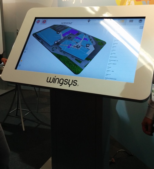
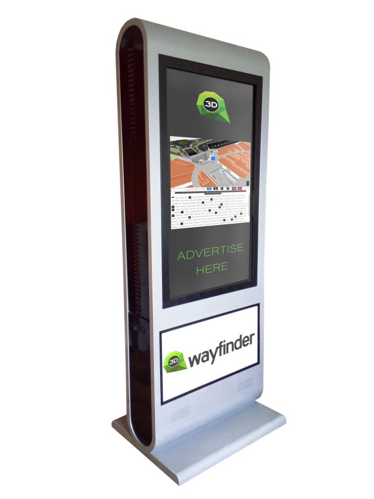
Wayfinder kiosk

Crystal chandelier hanging from the ceiling, marble floors and glass walls. Many shopping centers have this kind of interior design. Also, many commercial buildings or hotels have a more special and luxurious interior design. If the interior design of the building is characteristic of a high class, it is important that every detail fits together. Therefore, the kiosks must also have a luxurious and beautiful design.

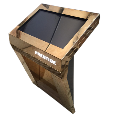
Kiosk designs may vary. For example, it is possible to decorate the kiosk with crystals or golden details. There can also be different materials from which the kiosk is made.

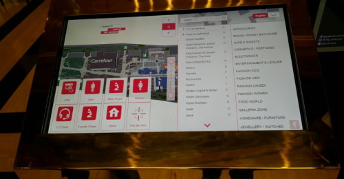
In the pictures you see a close-up of the kiosk app. You see golden design and a complex map.

Kiosk wayfinding app in The Avenues mall in Kuwait


Kiosks in Lõunakeskus are made of wood. Kiosk is designed following shopping center interior and brand design. Finally, a beautiful wooden solution is ready, which fits with the interior and is user-friendly.
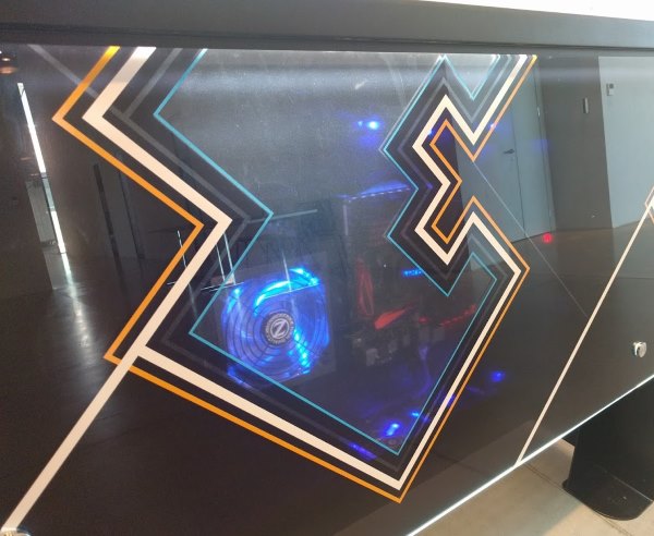
Estonian National Museum kiosk is made of glass. Kiosk has a metal frame, that supports the 8 mm tempered glass and holds the touch screen and computer hardware. Also it has a special “window” for looking at kiosk´s “heart”.

Estonian National Museum kiosk special “window”

Premium Wayfinder solutions

Small details make a 3D map especially luxurious. If you have a commercial building and want to impress your customers, we recommend ordering a particularly detailed map. The premium 3D map designs are suitable for buildings with a luxurious interior design. Detailed 3D maps are also suitable for expensive hotels or institutions visited by wealthier people. Detailed map of the building makes an impression in any case.

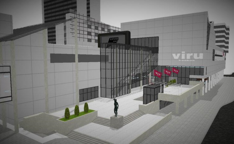
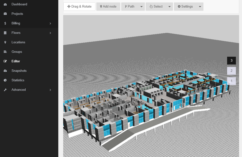
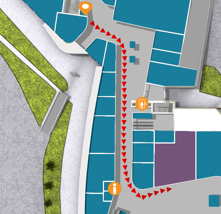
In the picture you see 3D relistic and detailed model of the Viru center. The flags, ornamental bushes and sculpture in front of the center have been drawn. For example, it is not possible to display such a sculpture realistically with a 2D map. Also, the exterior facade is as real as possible, and on closer inspection you can see transparent windows. This is premium detail. All exclusive buildings could have similar models.

Premium 3D model of Viru Center

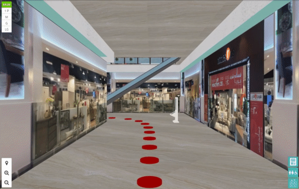
It is also possible to create a First person view wayfinder solution. The post shows one of the shopping malls in Oman. A 3D map drawn in detail looks good and it is especially useful for showing path in camera view (First Person View known from computer games). Such models affect positively the customer experience. Especially if it is possible to find favorite stores and special offers in the shopping center with the help of 3D wayfinder. It imitates persons point of view. The first person view house manager solution is definitely one of the premium feature that a luxury building needs.

3D Wayfinder first person view
Camera view (first person view) of Muscat Grand Mall in Oman

You can order a detailed and beautiful 3D map from us. In this case, our team of specialists will prepare you a gorgeous and detailed 3D map solution that will impress all your customers. Also, tell us all your wishes regarding the design of the kiosk and we will find the best solution together.

« »

Turning the Map, Based on the Location of the Kiosk

January 2, 2019

Lately we developed a wayfinding software for a newly renovated mall in Tartu, Estonia. The solution there is simple with just 2D map with no possibility to rotate or drag the maps on the screen. Users get to choose their point of interest on the menu and a route pops up on the map leading the way. In case the location is on another floor, the software simply switches around to show the route on the correct floor.

As 3D Wayfinder is a web-based application, then each kiosk is using web browser with kiosk specific URL for the wayfinding project. The URL specifies kiosk ID, so that wayfinding software can identify which kiosk is being used and count usage statistics. Also URL parameter can specify the rotation of 2D map.

How it´s work?

To make it easier how it works we bring you an example of changing the URL:

1)Let’s say that you have a kiosk with ID number 1. Normally the URL for that kiosk would look something like this: http://clients.3dwayfinder.com/NameOfYourProject/?kiosk=1#!/

2) To rotate that you just need to add “&map2DRotation=90#!” after the kiosk ID number. Here’s an example: http://clients.3dwayfinder.com/NameOfYourProject/?kiosk=1&map2DRotation=90#!/

Here is an example of how the map looks on the kiosk inside the main entrance:

Screenshot 2019-01-02 at 13.55.53

The red “You Are Here” icons make the map universal. Below is an example of the same map being used next to another entrance, the picture is just simply turned toward the user of the kiosk and the “You Are Here” icon placed in front of that particular entrance. This additional solution makes the user experience a lot more straightforward.

Screenshot 2019-01-02 at 13.41.09

It is also possible to use different kind of arrows for the ”You are here” icon. This way it is simple for the users to understand which way they are standing and how the kiosk is placed in the mall.

« »

Using Widgets in Wayfinding Application

April 13, 2018

Wayfinding applications are not just maps with “You Are Here” dot anymore. There are many possible functionalities and widgets that our customers prefer to see on their wayfinding applications. 3D Wayfinders HTML-based user interface makes it really easy to add and use such widgets in wayfinding application.

As wayfinding kiosks are usually in visible places. Visitors would also like to find other kind of information than the building map and directory listing. Large shopping malls are usually accessible via intercity bus or metro stations. It is important to find the commuting schedules. Also in larger modern shopping malls. There are integrated cinemas, which would also like to show their programme.

Nowadays people have smartphones, that can show weather forecast and date beside the clock. But still one of the things our customers are asking for quite often. This is a clock integrated to the wayfinding application.

wayfinder widgets

We have created a NPM package ‘ng.clock’ for the widget. It can be found at https://www.npmjs.com/package/ng.clock. Demo of the clocks can be found here https://codepen.io/tonister/pen/qpyBgQ. This clock widget is made as an AngularJS 1.x Directive. The choice to use AngularJS is due to the fact that almost all our latest templates have been created using AngularJS.

3D Wayfinder user interface is created with HTML. It is easy to implement any widget or integrate bus or cinema schedules inside wayfinding application user interface. Although it might be good to mention that for some of these features the API licenses are not free. If they are free then they are very limited.

Thanks to HTML5 based layouts it is easy to integrate different kind of widgets in wayfinding application. For example exchange rates, events, news, weather forecasts, social media feeds, CAP alerts, time remaining till closing.

« »

New Top View Feature in Our Editor

January 2, 2018

Sometimes it’s the small things that make all the difference. New “Toggle top view” feature in 3D Wayfinders administration panels editor is a useful tool that will give needed help to our users.

Toggle top view shows all the maps straight from the top and it works with both 2D and 3D maps. While this feature is selected, the rotation is disabled. This is most useful when marking paths on the map. It could also be used if you want to set kiosk view straight from the top on 3D maps.

New feature in editor

“Toggle top view” can be found on the top of the editor under “Settings“.

« »

Wayfinder With Digital Signage Software

November 2, 2017

We have tested 3D Wayfinder integration with Digitalsignage.com software. Integrating wayfinding with digital signage media management gives additional purpose for advertising screens.

DigitalSignage.com is created by MediaSignage Inc. It is free digital signage software. Including signage player and media content management. Their software is used in over 200 countries. Since the first release, the software has been installed on hundreds of thousands of PCs.

DigitalSignage.com software is web-based. So it is really easy to use 3D Wayfinder as a part of the media player screen layout. Let’s say, that there are top and bottom advertisement banners on the portrait screen and wayfinding application is set-up on the middle of screen.

Wayfinder kiosk

Screensaver mode

More advanced integration is switching advertisements with wayfinding application. This is something, we call “screensaver mode” when creating layouts for 3D Wayfinder. With Digital Signage software the simple way is to switch between wayfinding and advertising screen. Digital signage itself lets you create switching timelines, channels and content. We do not go into that much. Because there are plenty of examples in their documentation.

More sophisticated way to change between 2D map and screensaver can accomplish with event and triggers. Under Digitalsignage.com documentation http://docs.digitalsignage.com/ look for remote values. It describes what should be include in your app to be able to send event to their server.

Two functions that are important in 3D Wayfinder events case are ‘onSessionStart’ and ‘onSessionEnd’. They both are used by our statistics module. But if you do not have any need for statistics then you could overwrite these functions.

With signage free version you can use our 2D map with ease. Just include HTML component into your campaign and add link to your project.

digital signage

From documentation we could find out that signage players HTML component does not support webgl. But according to docs we should be able to get out 3D maps working with Browser component and signage player should be working on windows machine. Browser component is available for enterprise users.

« »

New Administration Panel is Up and Working

September 7, 2017

It has taken some time and lots of effort but we have finally made it. New 3D Wayfinder administration panel is finally online and usable for all clients.

new admin

We have made many smaller and bigger improvements to make 3D Wayfinder administration panel  easier to use. Especially for new clients. For example the editor has been changed to make it more logical. All the materials have previews for better overview and managing of 2D maps is more convenient.

It should also be more comfortable for those who prefer to use our app on smartphones or tablets.

There are still some kinks to straighten out so if you notice something that isn’t working the way it is supposed to, let us know.

“Sign in” leads straight to new administration panel but if you prefer to use the old one, go to old.3dwayfinder.com or use the link at the bottom of the sign in page. 

« »

New Features in 3D Wayfinder

January 15, 2016

With the end of 2015 and the beginning of this year there are many new features added to 3D Wayfinder. The goal of these changes was to add flexibility to customizing the behavior of the 3D map and wayfinding. Custom models for path, path types, POI options and many more.

In parallel with large customer projects, we have added many new features to 3D Wayfinder. Most of them were requested by our customers and we have added them as features/settings for all our users. Below are listed the most important ones.

Custom models for path visualizationcustom_path_models_wayfinding

It is now possible to choose your own custom models for path visualization. Path models can be different kind of arrows, footprints or simple tubes/lines. Changing path visualization models can be done under settings.

In near future we’ll add some sample path models also to our blog.

Path types and accessibility paths

It is now possible to add different kind of inaccessibility attributes to the path . This can be used for defining paths  that are also accessible with wheelchairs and/or baby strollers. This also enables defining other kinds of areas, like paths for service personnel etc.

Currently it has to be entered to the node attributes in json object format:

{

“inaccessibility”: [

 “wheelchair”

]

}

wheelchair_wayfinding_inaccessibility_Path_types_and_accessibility_paths

The nodes with these kind of restrictions cannot be used for path finding with “wheelchair” option. It is useful to set these restrictions for stairs or doors.

To use the inaccessibility in user interface, you have to change the accessibility option first:

this.wayfinder.accessibility = “wheelchair”;

Then it is possible to use the same show path method:

this.wayfinder.showPath(poi.node, poi);

And after showing path, just change the accessibility option back to blank:

this.wayfinder.accessibility = “”;

Also check out our blog post about how to set up time dependent navigation rules.

POI specific options

Advanced_POI_settings_specific_options

It is now possible to create special settings for each POI (location). These settings can be chosen from the list of all POI settings, like the size of the billboard image or billboard text size, highlight color, activation radius, billboard height etc.

This feature allows to customize the map by locations, for examples larger shops can have larger texts or text colors can be set by each shop. Also it makes easier to use logos or icons on the map, as the billboard images don’t have to be the same size anymore.

In the future it is possible to add new settings that can be used when developing your own template.

Top-down view for Path showing

path-top-down-view-for-path-showing

Now there is a simple option under settings to turn the map to top-down view when showing the path.

In general it is not a good idea to show the “You are here” location from top-down view, but rather  from certain angle (especially when it is possible with real 3D models as in 3D Wayfinder), which provides a better overview of the map and also makes the map look better.

Now when using the same angle, as displaying the “You are here” location, and visualizing the path, it may happen that the visualized path might not be visible. This is due to tall objects like walls that might block the view of the path. Using the top-down view during path visualization solves this problem.

Pause options between changing floors

According to valuable customer feedback, the transition of switching floors happens too quickly , which might be a bit confusing for the end-users. We solved this issue by adding the “pause-time” option to the settings. With this option it is possible to adjust the duration of the pause before switching to the next floor. The pause duration can be defined in seconds,  which makes it easiest to find  the proper delay that helps  all wayfinder users to understand, which floor they have to go to.

Kiosk view enhancements

In addition to being able to save the view angle, it is now possible to save the zoom factor for “kiosk view”. By clicking the “You are here” button, the map assumes the “kiosk view” saved in the editor.

In the future we will add this view option as a separate object so the view can be linked with any location or node.

« »

Towards Rule-Base Wayfinding

September 25, 2015

Future in wayfinding includes definitely possibility to create complex rules for path finding. Now there are also node restrictions in 3D Wayfinder to specify working days etc.

One of the last addition to 3D Wayfinder was node weights for calculating optimal paths. This made possible to guide visitors in some recommended way. Now there is also possible to restrict some nodes based on time and day.node_restrictions_wayfinding_paths_by_date_and_time

In many public buildings, there are rules for locking doors, elevators or gates. There can be different areas open during working hours than weekends or night times. This is common for shopping malls, train stations, university campuses etc. Even large office buildings are keeping some doors open during the weekends as there might be service providers like dentists, children playrooms etc. When providing wayfinding to your visitors, it is important to follow the same rules.

With 3D Wayfinder, it is possible now to create path restrictions according to work-day and time. To create this kind of restrictions, just open node attributes under editor.
Under Node attributes in 3D Wayfinder Editor, there can be entered JSON. In future we will provide also special UI for that.

Here is the example that will allow to pass the navigation node from 10AM to wayfinding_paths_restriction_node_attributes9PM:

{
“allowedTimes”: [
[
10,
21
]
]
}

Adding other blocks, you can also specify by days.

We are currently developing also other rule types, like security or accessibility. These rules help to create adaptable and user-friendly way-finding applications which are useful and finally elementary for large buildings.

« »