Faster Loading of 3D Projects

April 25, 2017

We have changed the logic of initializing POI data in 3D Wayfinder. This gives up to 80% faster project initialization for medium and large projects. In very large projects, the increase is even larger – more than 90%.

After data is loaded from the API 3D Wayfinder system had to setup the 3D scene. That also included generating polygons and textures for each POI. These included a POI icon or the name of the POI on a billboard (facing the user all the time). POIs without icons needed to have the name displayed but the only way to display a text in 3D space is to generate or load a image. So we used a canvas element to draw these names. But this is a costly procedure. 

Now we create only these images that are flagged as “Always visible” at the start. So the startup time is a lot faster. Check the following comparison table. That gives faster loading of 3D projects. 

Project Before After Setup Gain Total Gain
Medium 765 ms 174 ms 77,25% 5.63%
Large 6563 ms 1039 ms 84,17% 11.52%
Very large 26710 ms 403 ms* 6627% 54.86%

* Project doesn’t have any “Always visible” POIs

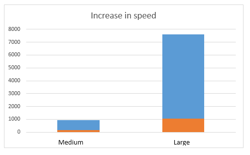
Initialization time before and after change compared with medium and Large projects:

wayfinder_loading_speed_increased_grapgh

Initializing is only a part of the whole loading. Loading the data and 3D models from server is another component of the whole loading process, so the afterall loading process is better about 5-55% (with connection 20Mb/s).

« »

Showing Multiple Floors in Path Animation

March 20, 2017

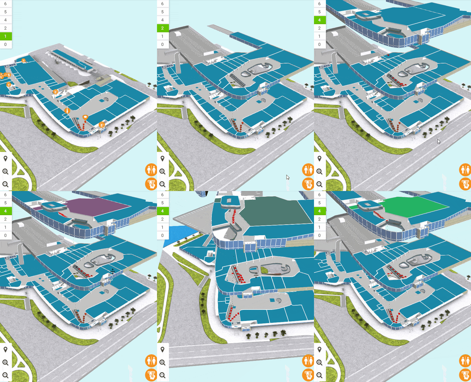
New feature we have added for wayfinding applications is accordion style floors when using path animation. This means, that all floors will be visible on the screens when showing the path through multiple floors.

In 3D Wayfinder you will see all floors as they exist in real building, so they are just simplified 3D models of the real floor-plans. When switching between floors, new floors will drop into scene on top of the previous floors or fly away, if going downward with the path. All floors are exactly covering previous ones, so basically whole 3D building models are sliced by floors.

Now it is possible to keep the floor plans apart from each other, so you can see all floors at the same time. This is useful mainly for wayfinding, so it is easy to remember the whole route. But we will definitely develop this “accordion” mode further, so it can be used also in other applications. For example in BIM applications, it is possible to highlight objects in all floors at the same time. Or visualize the whole factory with multiple floors or create multi-layer metro station animations.

Animation_floor_animation_in_3D_wayfinder_optimize

Currently the distance between floors is configured under settings. In future we will add features for separating the floors by dragging the floor-buttons apart. This makes the browsing of 3D buildings much more flexible.

To use this accordion style path animation, go to Settings in Administration panel. Then find Path->3D->Leave a offset between floors. For example use 50 as an offset, and then see how it looks.

« »

New Responsive Template for 3D Wayfinder

March 7, 2017

New template is now available for all 3D Wayfinder users. Template called “Iglu” is responsive HTML5 based template for 3D Wayfinder with clean and modern design. It is open-source and uses our newest AngularJS framework based template.

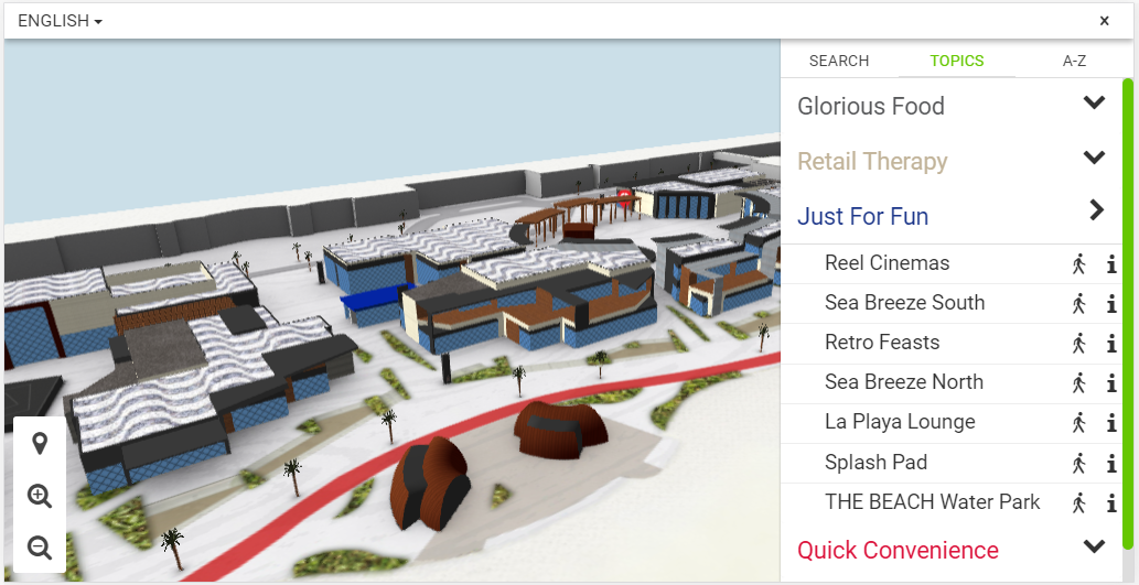
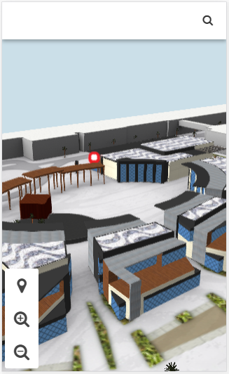
There is a new default template for all 3D Wayfinder projects and it’s called Iglu. Currently this template can only be used to view 3D projects. But rest assured we’re working on the 2D version as well. The 2D template will have exact same layout and styles as the 3D version. The main feature of this new template is the use of AngularJS. In addition to this there is one more major feature being added and it is responsiveness. This means that it can be viewed in both portrait and landscape mode. It will look good on all ranges and sizes of displays, be it a 55” kiosk screen or a 5” smartphone with WebGL support.

3D_Wayfinder_iglu_template_landscape_tablet

The template has three main sections which are the header, the map and the menu. The header has the building logo and button for activating the navigation menu. Below the header is the map that has map controls on it: floor buttons, zoom buttons, shortcut buttons.

3D_Wayfinder_iglu_template_potrait_mobile_map

Navigation menu

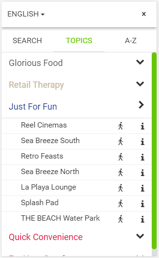
When the navigation menu is activated it will cover the right side of the map on larger screens and the whole map area on smaller screens. Currently the navigation menu has three tabs – the alphabetical listing, the category listing and search.

3D_Wayfinder_iglu_template_potrait_mobile_directory

Our new template covers all main features, needed for wayfinding:

  • Map navigation controls
  • A-Z list of all locations
  • Categories
  • Location info
  • Search

Although the template suites very well for wayfinding kiosks and mobile applications. It is also good for just showing and browsing 3D architectural models.

Here can You view a demo project based on the new template:
http://static.3dwayfinder.com/projects/demo/Iglu3D/

The Iglu template is based on our 3DWayfinderNGTemplate and it is open source (Github: https://github.com/3dtech/3DWayfinderNGTemplate).

The template uses 3DWayfinders AngularJS service. 3DWayfinderAngular (Github: https://github.com/3dtech/3DWayfinderAngular) – to communicate with our JavaScript Wayfinder API. So 3D Wayfinder functionality is easy to use in all AngularJS projects. The Iglu template is a clean and nice example of using AngularJS with 3D Wayfinder.

Our old default template called “default” is still available. It can be selected from menu or used direclty in wayfinder project URL: https://static.3dwayfinder.com/projects/demo/default/.
Template was made in co-operation with our development partner Iglu. Iglu is a young and innovative custom software building company in Estonia. Iglu’s core-competences are UX and modern front-end development.

« »

Compass Widget for 3D Floor Plans

February 15, 2017

We have added compass widget for Developers Template. Compass arrow can be shown on top of the map canvas to point to the north (or any other direction) of the 3D floor plan.

Compass is one of the tools and widgets that is needed for one of our larger building information (BIM) project. There are also other tools under development that provide building information and help work with different data related with building 3D model.3D_Wayfinder_using_compass_widget

Compass widget is using 0-point of the Y-axis. It is called with Camera view-port service orbitController.  It has property currentRotation, which holds the model’s rotation data.  Needle of compass is animated using that data.
Compass example is integrated into Development template. Template can be accessed via the administration panel at admin.3dwayfinder.com when selecting the view with template “DevTemplate”.

When using compass, it is important to notice, that the 3D floorplan has to be modelled north pointing to Z axis. Otherwise you need to make adjustments in widget’s javascript code, which calculates the compass’ position.

« »

15% Performance Gain for Larger 3D Floor Plans

January 31, 2017

We have improved our 3D rendering engine. Thanks to better memory management we got 10..20% performance increase in FPS with larger 3D models.

We updated our WebGL javascript engine – FRAK – in 3D Wayfinder. Many memory management functions have been improved in the new version. With the new FRAK engine 3D Wayfinder provides better loading speed performance for larger 3D models, that use more memory. With smaller 3D models, the increase in speed is not noticeable.

Testing with one really large shopping mall floor plan we got increase in performance in average 15%. In idle mode we recorded 16 frames per second (FPS) increase, jumping from 44 FPS to 50 FPS. While actively showing path we recorded a 7 FPS increase, jumping from 38 FPS to 45 FPS. In normal use, 3D Wayfinder is limited to 30 frames per second.

3D_wayfinder_webGL_performance_gain

« »

New Administration Panel Available for Testing

January 24, 2017

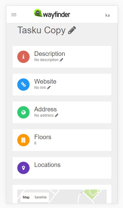
3D Wayfinder new administration panel is now publicly available for testing. It contains already most of the functionality and is optimized for mobile devices.

New admin panel is accessible for public use now. It can be opened here: http://admin2.3dwayfinder.com/

We have been redesigning 3D Wayfinder admin panel for almost half a year now. During the development of the new administration front-end, we have rebuilt many services in back-end also. Goal has been set accessibility from mobile devices and simplification.

new_layout_3D_wayfinder_optimized_for_mobile_devices

New administration panel is optimized for mobile devices:

mobile_layout_3D_wayfinder

There are still many bugs and we are working in full load to fix them. Any bug reports can be reported to our support. We would be happy for any comment or suggestion also. More detailed overview coming soon.

« »

Wayfinding Software Full Specification Published

December 5, 2016

We have published wayfinding software full specification feature list. This covers the important features for wayfinding and building directory administration.

3D Wayfinding has a lot of functionality and features. That might be not visible with first test use. For making the selection of wayfinding application easier and giving. We have published full specification sheet also in 3D Wayfinder webpage.

Wayfinding software full specification feature list is structured by following listing:

  1. User interface
  2. Wayfinding
  3. Searching and directory browsing
  4. Offline use
  5. Mobile application
  6. Positioning
  7. Floorplan administration
  8. Advertisments
  9. Statistics
  10. Integration and API
  11. Floor plan models

Please find the full feature list here.

« »

Branding Your Wayfinder Application

October 11, 2016

With 3D Wayfinder you can brand your wayfinding application just like it has been developed by yourself. It is possible to use custom loading bar and even get your own layout for administration panel.

We are using small watermark with 3D Wayfinder logo on 3D floor plans. But this only appears, when you are using free plan. As soon as you choose another plan, the watermark disappears.

Branding_your_wayfinder_application_using_enterprise_license

When using the Business plan it is possible to customize the loading bar of your wayfinder application.

brand_your_wayfinding_application_with_enterprise_license

With the Enterprise license it is even possible to change the branding of the Administration Panel. This way you can offer the 3D Wayfinder under your branding or integrate 3D Wayfinder inside your digital signage solution. For Enterprise licensing, please contact us.

« »

Guidelines for Creating 3D Models

June 14, 2016

We have listed some guidelines for creating 3D models, that look nice and run smoothly in web-browsers. 

3D Wayfinder uses regular 3D models, so there is no special format or way how the 3D floorplans should be modeled. As 3D Wayfinder works in web-browsers through WebGL technology, then in order to get better results the 3D models should be optimized. Read below for some useful tips and tricks on optimizing 3D models for the best performance.

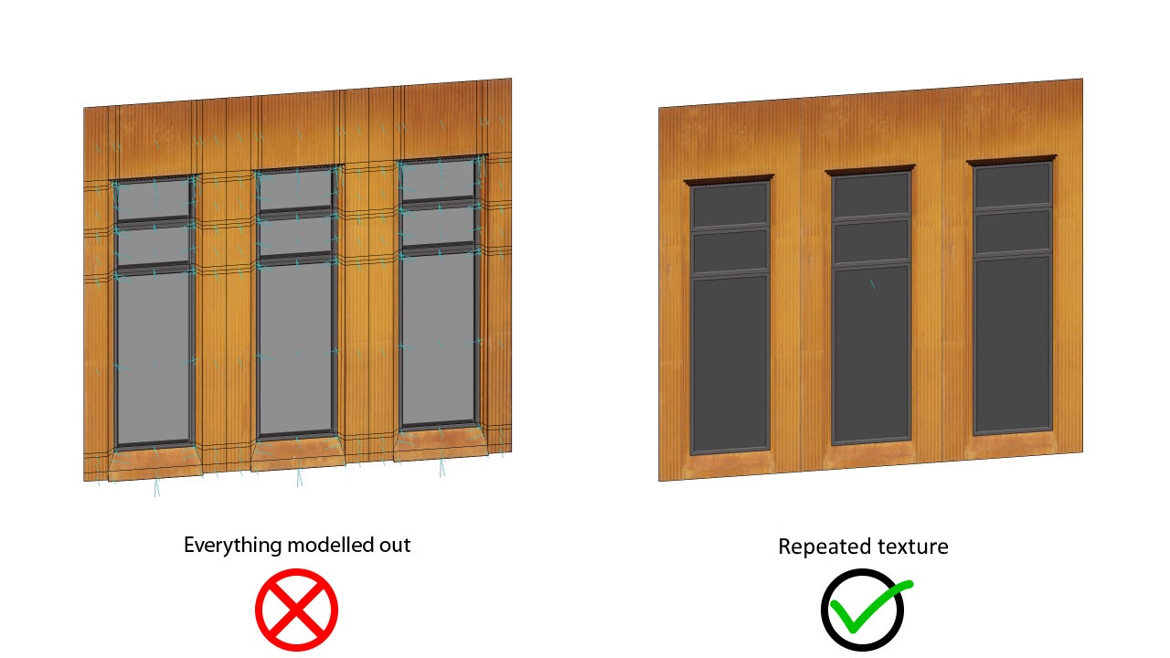
For example keep the 3D geometry simple and use textures, that can be repeated:

Guidelines_for_creating_3D_models_repeating_texture

An important element of 3D floorplans are different kinds of vegetation (trees, bushes etc.). They help to make the floorplans look more life-like and in some cases are also important for navigating on the map. It is easy to use transparent textures on the simple planes, just never model out the leaves or branches:

Guidelines_for_creating_3D_models_transparent_PNG_texture

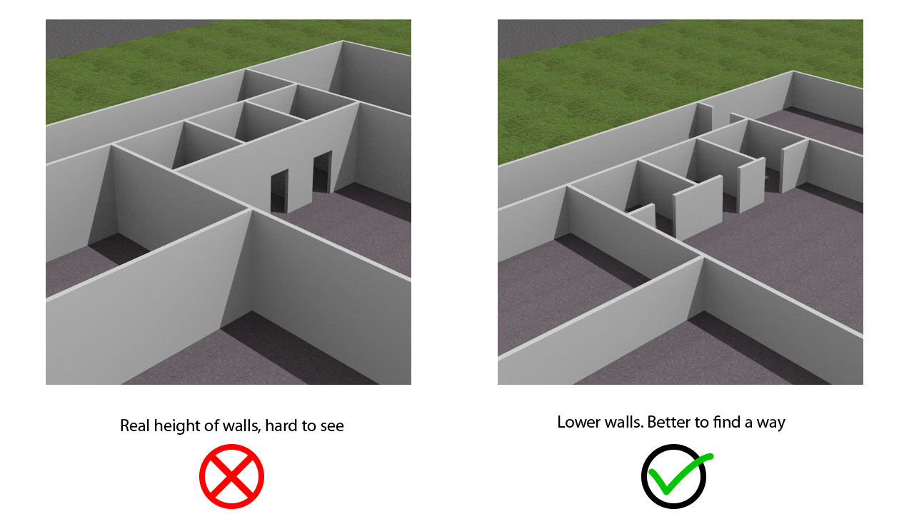
With 3D it is possible to create really life-like buildings, but when using 3D for maps, it is always good to keep the models simpler. For this we suggest removing un-important furniture and making the walls as low as possible without losing the general idea of the height of the room. This way the visibility of the visualized path is far greater.

Guidelines_for_creating_3D_models_lower_walls

You find the full list of guidelines for creating 3D models are added 3D Wayfinder page here.

« »

Moving Camera According to Path

March 2, 2016

There is option now to moving camera with path animation. This makes the path visualization even more effective with 3D floor-plans and maps. Especially when combining with directions.

So far there were 2 ways to show the path: draw the path animation or show the walk from first person view. Like you see the 3D in computer games. With usual path visualization the map was zoomed out, to fit the whole path on the screen. But this might make the understanding of recommended path a bit complicated. Mostly when the map is large and complicated.

moving_camera_with_path_animation

With moving the camera with path animation it is possible to keep the “You are here” view to the map, including angle and zoom level. Of course it is always possible to zoom in or out during the path animation and rotate the map (if it is allowed). The camera will keep following the path to the guided destination.

Path visualization behavior can be adjusted under Settings in 3D Wayfinder Administration panel.

« »