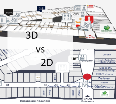
Offline Indoor Wayfinding

July 29, 2015

3D Wayfinder provides offline snapshot add-on to create static wayfinding application that can be used without internet connection. Read more about offline indoor wayfinding. 

Offline_Indoor_Wayfinding_with_3d_wayfinder

When kiosks or digital signage screens don’t have internet connection, then there are 2 options:
1) to use offline snapshot or
2) to install the 3D Wayfinder Enterprise Server locally.

Offline indoor wayfinding snapshot Add-on enables to save 3D Wayfinder projects for offline use. The add-on creates static files of all the assets and modifies the template file for local use. Also to use the snapshot files You need a local web server. Because modern browsers do not allow requests to local files. Read more from the offline snapshot tutorial.

Kiosk or totem set-up is the same as with using 3D Wayfinder from the web.

The only thing with offline snapshots is that after each update the files in kiosk need to be updated.

We are also offering 3D Wayfinder Enterprise Server with Administration panel and everything else, that is needed to administrate wayfinding kiosks locally. For more information, please contact our sales team.

« »

3D Wayfinder Joined the Open Design Alliance

June 19, 2015

We have joined the Open Design Alliance to develop CAD file support to 3D Wayfinder. With CAD support it will be easy to upload building drawing files and show them directly through web.

Open_Design_Alliance_logo_wayfinder

3D Technologies R&D (developer of 3D Wayfinder) is now a member of Open Design Alliance. The Open Design Alliance (ODA) is a nonprofit organization dedicated to the promotion of open industry-standard formats for CAD. ODA was established in 1998 and now has over 1300 members.

Most of the architectural modelling is done with Autodesk CAD software packages, where DWG files are native file formats. DWG is a proprietary and closed file format and it doesn’t have open specifications. ODA has deigned Teigha library which supports the use of C++, .NET, and ActiveX interfaces. Also it allows the exchange of data through .dwg, .dgn and .stl files.

We will search the possibilities to provide also DWG file reading in 3D Wayfinder. This will open up a whole new area for 3D Wayfinder. Architects can directly upload their building drawing to 3D Wayfinder and also real estate managers, building owners etc. For example DWG files that can be viewed through 3D Wayfinder. There will be no need for converting DWG-s to common 3D formats that 3D Wayfinder currently supports.

« »

Welcome Screen for Wayfinding Application and Changing Farme-Rate for FRAK

June 8, 2015

Some of our customers prefer a “Welcome” screen for their wayfinding application. Welcome screens are good way for inviting visitors to use wayfinding, it is also a page where you can show advertisements or welcome text. To minimize the load for kiosks we change the frame-rate of our WebGL rendering engine FRAK. 

wayfinding_welcome_screen

Welcome page is configur as an idle-page, when no one is using wayfinding. Usually it is set to 10+ seconds after idle time, when the welcome screen is displayed. On this view, we are hiding wayfinder map component and directory. When visitor starts to use wayfinding, then welcome screen close and floor plans with directory are activate. Certainly, the welcome screen is also helpful for customers to understand what the screen is about. Also a great way to advertise for businesses located in the mall.

To save the kiosk pc and graphics card (GPU) we set the 3D rendering (see FRAK WebGL engine) also idle. This is important for limiting the frame-rate to a minimum. Frame rate change can be invoke with Engine.startIdle(fps) and return to normal operation with Engine.stopIdle(). See 3D Wayfinder API for specific documentation.

We have also fixed a bug in SmoothOrbitController that made animations oscillate on very low frame rates.

« »

3D vs 2D Wayfinding

May 18, 2015

What is the difference between 3D vs 2D wayfinding and what are the benefits of 3D floor plans?

We have tested 3D, semi-3D and 2D floor-plans with our small focus-group and below is the short summary.

3D_vs_2D_wayfinding_maps

To see the 3D floor-plans in action, please sign up to 3D Wayfinder for creating your own 3D floor-plans, or see our 3D modelling services and examples.

3D Wayfinder supports also 2D images for creating wayfinding application.

Semi-3D maps are rendered or designed floor plans, that are made to look like 3D. The map is rendered on an angle, so it is possible to see part of walls also.

We are using semi-3D maps for mobile devices, where WebGL is not supported yet.

3D vs 2D wayfinding floor plans

 3D floor plansSemi-3D floor plans2D floor plans
Overview of the building
  • 3D floor plans give a good overview of your location.
  • With 3D users see the map the way they see the building in real life.
  • It is possible to show the details, that people use for orientation inside building, for example escalators, pools, statues, tables, benches, trees etc.
  • Showing walls give a better understanding of where you are and it is easier to link the map with a real building.
  • It is easy to understand which floors have atriums and distinguish between things on different plains.
  • Semi 3D floor plans give also a good overview where you are.
  • Semi 3D can be shown only from the one angle, when looking from the other side, they can be are hard to understand.
  • Limited possibility to show the walls of the building.
  • Detailed 2D floor plans don’t give a clear overview, so it is better to use simple floor plans.
  • With simple maps the amount of details are limited.
  • It is hard for users to understand where they are and linking the map with real building is not that convenient.
  • With 2D it is not possible to show the walls of the building.
Usability of wayfinding application
  • 3D floor plans are easy to use. It is always possible to limit the zoom distances and even forbid rotation if needed.
  • Pathfinding is simple and 3D gives a good visual overview for navigating from one floor to another.
  • It is always possible to use camera view for path visualization.
  • Extra dimension enables to add more info.
  • Semi 3D floor plans are also easy to use, but it is not possible to rotate the maps.
  • Pathfinding is more convenient than 2D, as users can see some parts of the walls.
  • It is possible to add more info to the maps as 2D, but it is still not possible to add as many info/layers than 3D.
  • Rotating and moving is not that convenient, especially when looking on the vertical screen.
  • It is not convenient to guide visitors to other floors.
  • 2D floor plans should be kept simple, as there is limited space for layers and info.
  • Simple maps may not provide enough information and visitors may think, that the maps are not useful for them.
Map details and amount of information on the floor plans
  • With 3D there is one more dimension for presenting details and map related data.
  • Billboards on the map don’t disturb browsing.
  • It is possible to show details for better orientation.
  • It is possible to add more details than 2D maps, but the space for information is still limited.
  • Level of details should be kept as simple as possible, otherwise they disturb the understanding of the map.
  • Illustrated details cannot be presented in real size and it can be confusing.
Impression and imago of the building
  • 3D floor plans look nice and realistic.
  • Visitors have a sense of „controlling the building”, which makes them feel good
  • Users understand, that there has been more effort to make the wayfinding for them as good as possible.
  • Semi 3D looks prettier than plain 2D map.
  • Visitors may get disappointed when they try to turn the building, as they expect it to be real 3D.
  • With too simple 2D maps it is possible, that visitors may avoid using maps not to look foolish.
  • Detailed maps confuse visitors and they feel more lost than they were before stepping in front of the wayfinding application.
Displays and future technological possibilities
  • 3D wayfinding can work also with real 3D technologies like holograms, LED-cubes and 3D displays. Unfortunately these technologies are still in prototype phase.
  • With larger displays it is possible to add more details.
  • There is no reasonable point of showing more details with larger screen.
Advertising channel and Digital Signage integration
  • More advertisements can be shown on the maps, as the ads don’t hide the map.
  • Billboard ads on the maps look cooler and attractive.
  • Better than 2D but the advertisements still hide the map.
  • Advertisements disturb the using the wayfinding.
  • Less space for advertisements, as they hide the map behind them.

« »