Using 3D Maps in Ski Resorts

January 23, 2023

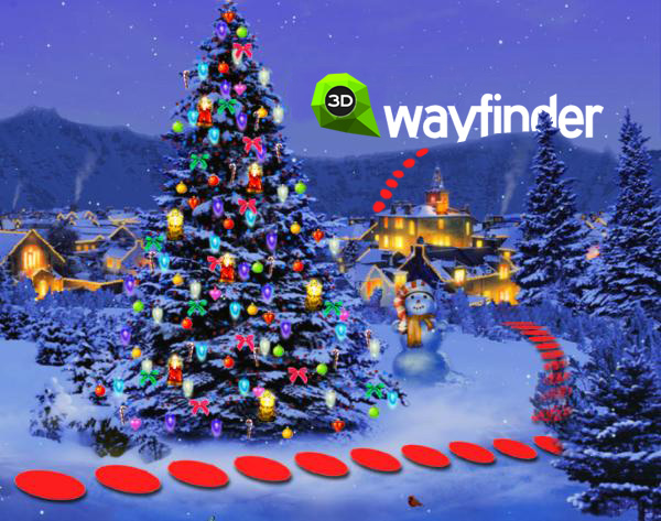
3D Wayfinder gives you innovative 3D map platform where you can build best ski resort app. All needed functions are available: 3D maps, positioning, guidance, search, filtering ski tracks and much more.

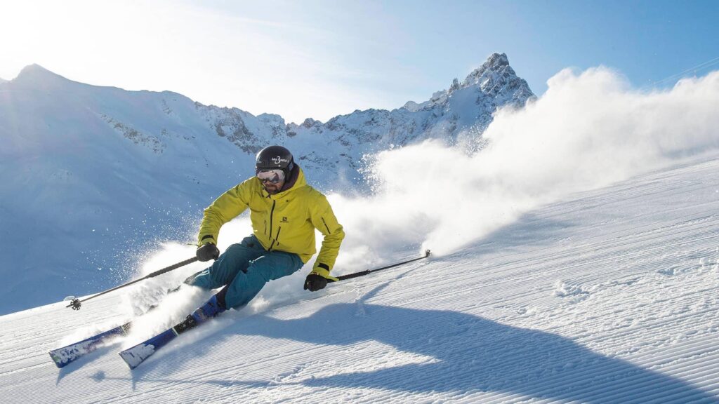
Alpine skiing is fun and many people love it. It is more than just taking the lift up and skiing down to the ski lift entrance again. Skiing is active vacation with everything it should include: planning trips, taking meals, socializing etc. You can plan your ski-routes as the longest ski tracks can be more than 10 kilometers long in Alpine region. While skiing down the hills you can enjoy the sun, have a drink in cafeterias and enjoy the social life.

3D Wayfinder gives you innovative 3D map platform where you can build best ski resort app.

There has been worries that ski resorts have less snow and the season periods of the ski resorts (when the ski-tracks can be opened) is decreasing. Weather it is temporary phenomenon or climate change is a different topics, but what we know is that ski resorts have to use modern technologies too. This is for providing better experience for all the skiers and snowboarders and manage the communication with visitors.

3D Wayfinder ski resort application

Ski resort app works on both, Android and Apple iOS, but the same way it can be used as a customized web-application or it can be embedded to any website (with some limitations in functionality).

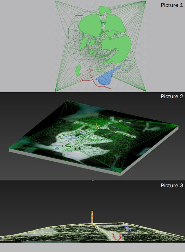
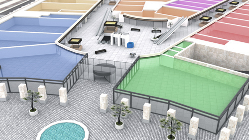
3D maps can be very detailed because ski hill, ski tracks, lifts and objects like forests and buildings can be added. The picture shows complexity of creating 3D maps based on regular height-maps. Later there will be added ski trails, trees, houses and lifts as 3D models.

3D maps can be very detailed. The basis of the 3D Wayfinder ski resort mobile application is that app works on both, Android and Apple iOS.

To estimate the work for modelling 3D maps of the ski tracks, please contact our sales.

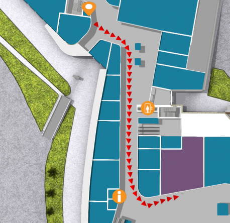
3D Wayfinder for ski-resorts can be accessed in different ways. 3D Wayfinder can be used in touch-screen kiosks. These can be weatherproof screens near lifts or entrances, or simple information kiosks near hotel receptions. Interactive 3D maps are certainly more advanced way to browse ski tracks than 2D drawings, we have mostly seen. 3D Wayfinder can be integrated to the website or used as web-based app. Printed signs or labels can use QR-codes to open 3D Wayfinder with the 3D map of the mountain or ski resort.

Positioning

3D Wayfinder uses Bluetooth beacons for indoor positioning as the GPS signal is weak inside the buildings. Positioning in ski resorts is much simpler as we can use regular GPS positioning. The mobile application (or web application) positions the user according to the GPS signal and will let user navigate from point A to point B. For alpine skiing, positioning allows user to see the the location so that he or she can see the tracks and find the nearest cafeterias or toilets or find the ski lift to another hill.

Application services in ski resort

3D Wayfinder offers several different options for creating a ski resort app. It is also possible to add several different services to the application. The system can be integrated with many other systems. In the application, it is possible to buy e-tickets using QR-code. In addition, you can mark the gathering places of groups anywhere on the mountain and sharing meeting point in messenger. It allow to plan your journey on mountain and select ski tracks based on your level and skills.

3D Wayfinder offers several different options for creating a ski resort app

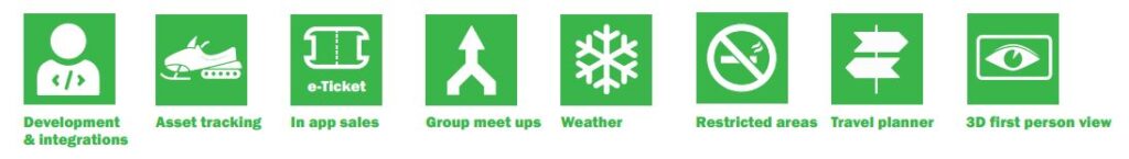
For large mountains there is possible to add help button. If in trouble or if user need of help from ski resort staff or emergency services. User just pushes one button and their location information with help signal is sent!

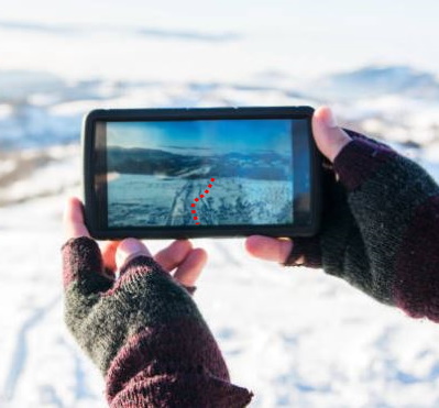
Also you can use the first person view solution, which is essentially a 3D replay from descending from ski mountain. To share on social media or keep as a memory.

3D Maps and First-Person-View

In ski resorts and mountains, it is important to use 3D maps. This is because you cannot see the other side of the mountain in 2D map, but in the ski hills it is important to see the other side of the mountain where you want to go as the tracks are usually not only in one side.

First-Person-View is the term from computer games. It means you will see the game through players’ eyes. By looking the route with First-Person-View, you see how it might feels to ski down the hills in real life. It is like simulation of the skiing, so why not to go through the planned tracks by looking route in 3D.

3D Maps in Ski Resorts app. 3D Wayfinder provides first person view solutions for ski resorts.

As the main land-marks on ski resorts can be modelled out in 3D, for ski lifts and tracks we can use vectors. This means that zooming out the map, will not reduce the size of the vectors. The same way you will see important roads on map applications.

For more information, please contact us.

« »

Installing iBeacons is Easy

November 14, 2017

We have finished installation of approximately 250 iBeacons for mobile app positioning. Although the installation process is easy. There are some tricks and common practises to follow, when setting up iBeacon based indoor positioning.

iBeacons installation

iBeacons are cost effective indoor positioning devices, that are really easy to install. As each iBeacon has it’s own battery, that can last about a year, then there is no need for external power supply. Devices are very light, so it is possible to mount them by using double-sided tape.

Even though the installation of one iBeacon is a simple matter. Overall installation process can be quite long and somewhat physically exhausting due to the constant climbing up and down the ladder/platform.

At first glance it might seem that the device will disrupt the look of the building. But, as we can see from the image below, if you take into consideration the overall theme and look of the building during choosing of the device, it merges into the plethora of different sensors and equipment covering the ceiling.

Installing iBeacons

Before installing devices. It is important to mark down the specifications for each iBeacon device. Each iBeacon has it’s parameters: unique ID, name and range.

It is also a good practice to mark the iBeacons. So that you know you’re installing the correct device to the correct location. For this we used a label printer.

iBeacon

Plan before iBeacons installing

It is good to have a plan before physical installation. We used the map of the building to first draw a layout of the placement of the devices and their coverage area. It is a common practice to have a minimum of 3 iBeacons covering any part of the mappable area for the navigation to work efficiently.

iBeacon coverage map

Configuring iBeacons in 3D Wayfinder is also easy. Just create a node with type “iBeacon” and enter iBeacon parameters (UUID, Name etc.). To manage all the devices from one place, open “Beacons” from the left-side menu. You can do this prior to the actual installation when you are confident that your layout will work.

iBeacon management

It is highly recommended to install the iBeacons to a height unreachable for the visitors of the building, so no one could easily snatch them. We installed the devices onto the ceiling. For this we used a painters platform that had wheels on them so it is easy to move it around the building. We recommend setting the platform to a height so the person installing the devices could stand up straight and then reach the ceiling without having to stretch too much.

Good time to install iBeacons in a shopping mall is when there are not that many people.

Here you can find more information about using iBeacons with 3D Wayfinder. If you’d like to test iBeacon-based positioning, please submit the request form for demo iBeacons.

« »

Indoor Positioning Demo with Custom Floors and iBeacons

July 18, 2017

Now it is possible to order indoor positioning demo application. For demo we will send you required amount of iBeacons devices and create custom 2D or 3D floor plan. With 3D Wayfinder mobile application it is possible to see indoor positioning with wayfinding functionality.

iBeacons are Bluetooth low energy (BLE) devices that can broadcast their identifier to nearby portable electronic devices such as mobile phones or tablets. Also iBeacons don’t cost much and their batteries can last over year which makes them perfect for indoor positioning.

 beacon1_2

We can provide you with a custom demo map with pre-installed iBeacon locations. We will also send beacons for the demo floor plan, usually 3-6 is enough for a 1-2 room demo.  

By installing 3D Wayfinder mobile app, you can test and see iBeacon-based positioning on your real building. To order demo map with beacons, please fill the request form.

Read more about 3D Wayfinder mobile app, iBeacons and indoor positioning.

« »

Choosing the Best Wayfinding Software

July 5, 2017

There are lots of different wayfinding software and it might be difficult to decide which solution to pick. We have used our experience and gathered some suggestions that will help you choose the best wayfinding application.

Over all the best wayfinding software application is always the one that adapts exactly to your specific needs. Having more options and can help to cater this.

Best Wayfinding software should be..

Wayfinding application should be easily integrated with other applications. One of the most common integration is showing social media content in wayfinding applications. As shopping malls and other public building usually have their news already on Twitter, they would like to include the news feed also in wayfinding.

path-top-down-view

Have a look at our wayfinding possibilities here.

You can choose to buy the product and do all the hosting and managing yourself. Or you can pay for this service. In that case make sure how much you can control the app once it’s up and running. Are you able to change the opening and closing times yourself? Can you add a new location and generate a path way? Or do you need to contact the company for every little change.

Look and feel customization is also something that should be provided. Choosing from existing templates is more cost effective than custom designs but even then it should be possible to change the basic things like the font, it’s size and colors.

Nowadays you can pretty much always choose between 2D or 3D maps. 3D maps are effective and showy on the screen, but it could be costly and time consuming if you want to change the location of the kiosk. The best wayfinding software should provide the option to use both.

3a

You should also check how accurate and detailed the maps are going to be. Although the best way to ensure accuracy is to provide correct data yourself.

Even if you want to use only information kiosks in the beginning, it never hurts to be prepared. If you choose the application that is also mobile friendly, it will save time and money in the future.

Indoor positioning and navigation

The indoor positioning and navigation ability is a must while using the wayfinder mobile app. Right now the iBeacon technology, that uses smartphone’s Bluetooth connection seems to be the most reliable one. Navigation system can also use WiFi networks but it is cost effective only in places like big malls, where every shop already has their own network.

nexus_5

When visitors are searching for something, targeted ads are most impactful. Customers can be attracted by giving out coupons, offering special deals, providing additional information. While nobody is using the information kiosk for wayfinding, the whole screen could be used to display ads.

And last but not least, the pricing. Make sure to find out beforehand what are you going to pay for. For example: will it cost more when you want to add another kiosk later?

There are some other questions you should ask:

Can you use the app online?

Is multiple language support provided?

Can the specific routes for disabled access be displayed?

Will the app collect user data for statistics?

To find the answers to these questions contact: info@3dwayfinder.com.

Have a nice summer,

3D Wayfinder Team

« »

Creating BIM Applications with 3D Wayfinder

June 15, 2017

3D Wayfinder is now being used for Building Information Model (BIM) applications. By creating BIM kiosk software for Estonian National Museum we have added many new and useful features to our software and improved the performance for larger models.

Estonian State Real Estate Ltd ordered Building Information Model solution from us for recently opened Estonian National Museum. Now the visitors can easily explore the 3D model of the whole construction. Also they get the overview of the building by all the details.

erm2016

What is BIM applications?

BIM model is a digital equivalent of the building. It can contain everything from doors to electric fixtures. Although BIM applications technology and methodology is more common in the design of the building. It has large potential benefits for buildings management and maintenance phase.

Estonian National Museum’s new building is meant both for exhibitions and scientific work with net area of 33 879 square meters. We received a model of a building made with Revit, Autodesk software for BIM. It contained highly detailed information – e.g. all the pipes – so it needed a lots of simplifying.

erm_wayfinder_BIM

After the adaptations we still had a huge file with close to 12 000 separate elements. It is the largest model we have had in 3D Wayfinder. It was also the reason why we changed the logic of initializing POI data to make the loading of large objects faster.

Table view for all objects in BIM model was done by using Spreadcell. Spreadcell has easy upload from MS Excel files and it provides table-view, sorting etc by webservices (in JSON format). All the objects are divided into separate groups so the final user can choose what do they want to see, hide or find.

ERM_wayfinder_BIM

Kiosk design

We also built and designed the kiosk from scratch. Since most of the modern kiosk hardware is only enough for showing advertisements or 2D wayfinding plans. The kiosk is equipped with a landscape LCD screen, a touch panel and a dedicated graphics card. It makes kiosk suitable for applications that require greater graphical computing capabilities.

ERM_BIM_kiosk

3D Wayfinder application helps to make BIM useful for those who have no access to specific softwares themselves. For example we can integrate BIM with different management softwares. Also add the ability to write comments. In this way we make it easier for different parties to collaborate on centrally shared model.

« »

3D Wayfinder Mobile Applications for Android and IOS

July 28, 2016

The development of our new 3D Wayfinder mobile applications for Android and IOS is in the final stages. It will be available in a short time. You will be able to create 3D Wayfinder applications for your venues and enable the download for people that will make it easy to find the way.

The app is based on the popular Ionic framework (Web based). Ionic is a very easy to setup and customizable mobile app framework. It uses AngularJS and Cordova. We will OpenSource the application source code so you can make Your own version.
We will also add Geolocation and iBeacon based positioning support in the near future.

« »

Node Weights in Path Calculation

August 21, 2015

We have updated path finding functionality and path calculation. Now it is possible to change the weights of navigation nodes in 3D Wayfinder floor plan editor.

Path-finding application calculates automatically the shortest route from the starting node to the required location. In mobile applications, the Kiosk node can be your position inside the building. With 3D Wayfinder, the shortest route is calculated in a 3 dimensional room. It means the shortest path through all the floors.

Now it is possible to change the weights of the connection nodes. With this wayfinding application calculates optimal route, which doesn’t have to be the shortest. For example when you would like to guide your visitors to use the path inside the building instead of going around the building. Then you can set the weight for outdoor nodes higher. The weight is basically virtual length that will be added to the route, when passing the navigation node with a weight.

path_finding_functionality_in_3D_Wayfinder
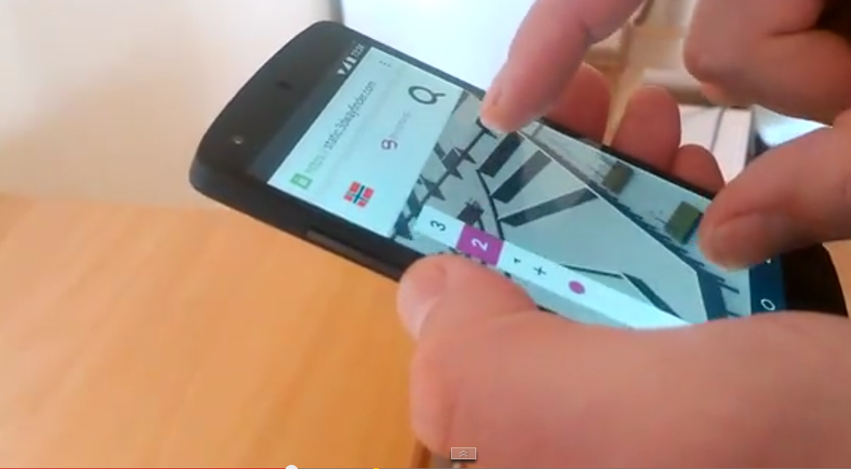
To use the weights you have to select the navigation node in 3D Wayfinder floor plan editor and change the node weight from the text box. By default all the weights are 0.

For example lets, say that waiting for the elevator takes usually 3 minutes. Lets assume, that visitors are moving with a speed of 3 km per hour, which is 50 meters per minute. So with waiting the elevator, visitor can pass 150 meters (3*50). If we would like to take account this in path calculation. Then we can add weight of 150 to the navigation node, that is marked as elevator.

Pathfinding functionality comes bundled in an add-on you can order from 3D Wayfinder Administration panel. It is also included in the Pro plan.

Read more about 3D Wayfinder’s path-finding capabilities.

« »

3D Wayfinder Redesigned Website Launched

February 17, 2014

We are proud to announce the release of our newly redesigned website which goes live today 17.02.2014. It is located at the same address www.3dwayfinder.com. New website is more modern and user-friendly. Improved and re-designed landing page welcomes visitors with clean exquisite design. With featured content focused on providing our clients and partners the most accurate product information. You will immediately notice simple navigation options. Also easy access to information that is important. The website will be updated on regular basis with news, events, product updates and other new contents.

We hope You will like and enjoy the new website. Also we would very flattered if You will stop by at the new site.

If You have any suggestions on how we could make the website even better, don’t hesitate to share it with us by clicking here.

Wayfinder

3D Wayfinder MobileNew website includes many improvements and new features. Some of the most important ones are listed below:

  • Improved navigation.
  • Precise overview of kiosk, mobile and web application.
  • Overview of different maps (3D, semi 3D and 2D).
  • Technical information.
  • Categorized resellers and their contact details.
  • New design is fully responsive. Which means You can now enjoy all of the content on mobile phones and tablets.

« »

Merry Christmas and a Happy New Year

December 19, 2013

joulD

The whole team of 3D Technologies R&D wishes You a merry christmas and a happy new year.

We will put additional effort into developing the software. All for better service and satisfaction for a user.

Just last year we could read that WebGL and HTML5 are not very well supported on mobile devices and have a long way to go. First tests showed that with a low polygon cont it was still lagging and mobile devices crashed often. Now things have changed and there has been a great leap forward – WebGL has started to mature and stabilize.

The mobile Internet speed is increasing every year and application downloading time is shortening. Telecommunications company EE announced recently that it has switched on the world’s fastest 4G network in East London which is capable of reaching speeds of up to 300Mbps. The fast mobile internet connection allows to download and use applications or online services faster and more conveniently.

Devices are becoming more and more powerful – each year more improved and advanced mobile processors roll out. For example MediaTek recently announced the MT6592, a mobile processor that includes eight cores with each capable of running at speeds up to 2GHz. It is the world’s first heterogeneous computing System on a Chip with scalable eight-core processing for superior multi-tasking. Fully functional WebGL on mobile devices is already here and we think that in few years or even less it will reach wider audiences. A prerequisite for this is of course technology’s lower prices and the increase of mobile internet speed.Here is the screenshot of the very first test of 3D Wayfinder WebGL on mobile device (Nexus 5):

If you want to be sure that your mobile device browser support WebGL then just click here. You can also check this summary table where is detailed data almost every desktop and mobile browser WebGL support.

« »

Why Consider Mobile Indoor Wayfinding?

November 19, 2013

According to Google, self-service is becoming the new norm – 1 in 3 shoppers use their smartphones to find information instead of asking the store employees. 74% of adult smartphone owners aged 18 and older say that they use their phones to get directions or other information based on their current location. (Source: Pew Internet)

Way finding outdoors is easy, because there are so many different navigation softwares guided by the GPS. But people also need an indoor wayfinding solution because buildings nowadays have become very complicated. There is a great need for a simple indoor wayfinding solution for mobile devices. Therefore we offer 3D Wayfinder mobile app for Android and iOS. Soon it will be available on Windows Phone as well. It helps people to navigate indoors and get the latest deals. It is a tool for retailers to advertise their brand or product on the map. The solution has many benefits:

mobile-4

  • Instant updates – building owners can provide the latest maps and directions for the audience using Content Management System;

  • Additional services – integration with social media channels or other solutions;

  • Happy customers – personal wayfinding system and instant directions for everyone;

  • Powerful e-commerce tool – tenants can promote their shops and products.

« »