Using 3D Maps in Ski Resorts

January 23, 2023

3D Wayfinder gives you innovative 3D map platform where you can build best ski resort app. All needed functions are available: 3D maps, positioning, guidance, search, filtering ski tracks and much more.

Alpine skiing is fun and many people love it. It is more than just taking the lift up and skiing down to the ski lift entrance again. Skiing is active vacation with everything it should include: planning trips, taking meals, socializing etc. You can plan your ski-routes as the longest ski tracks can be more than 10 kilometers long in Alpine region. While skiing down the hills you can enjoy the sun, have a drink in cafeterias and enjoy the social life.

3D Wayfinder gives you innovative 3D map platform where you can build best ski resort app.

There has been worries that ski resorts have less snow and the season periods of the ski resorts (when the ski-tracks can be opened) is decreasing. Weather it is temporary phenomenon or climate change is a different topics, but what we know is that ski resorts have to use modern technologies too. This is for providing better experience for all the skiers and snowboarders and manage the communication with visitors.

3D Wayfinder ski resort application

Ski resort app works on both, Android and Apple iOS, but the same way it can be used as a customized web-application or it can be embedded to any website (with some limitations in functionality).

3D maps can be very detailed because ski hill, ski tracks, lifts and objects like forests and buildings can be added. The picture shows complexity of creating 3D maps based on regular height-maps. Later there will be added ski trails, trees, houses and lifts as 3D models.
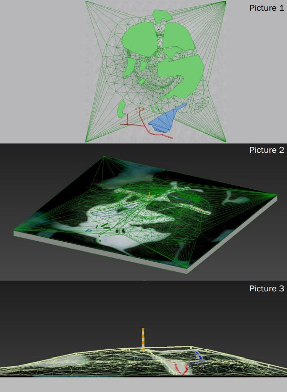
3D maps can be very detailed. The basis of the 3D Wayfinder ski resort mobile application is that app works on both, Android and Apple iOS.

To estimate the work for modelling 3D maps of the ski tracks, please contact our sales.

3D Wayfinder for ski-resorts can be accessed in different ways. 3D Wayfinder can be used in touch-screen kiosks. These can be weatherproof screens near lifts or entrances, or simple information kiosks near hotel receptions. Interactive 3D maps are certainly more advanced way to browse ski tracks than 2D drawings, we have mostly seen. 3D Wayfinder can be integrated to the website or used as web-based app. Printed signs or labels can use QR-codes to open 3D Wayfinder with the 3D map of the mountain or ski resort.

Positioning

3D Wayfinder uses Bluetooth beacons for indoor positioning as the GPS signal is weak inside the buildings. Positioning in ski resorts is much simpler as we can use regular GPS positioning. The mobile application (or web application) positions the user according to the GPS signal and will let user navigate from point A to point B. For alpine skiing, positioning allows user to see the the location so that he or she can see the tracks and find the nearest cafeterias or toilets or find the ski lift to another hill.

Application services in ski resort

3D Wayfinder offers several different options for creating a ski resort app. It is also possible to add several different services to the application. The system can be integrated with many other systems. In the application, it is possible to buy e-tickets using QR-code. In addition, you can mark the gathering places of groups anywhere on the mountain and sharing meeting point in messenger. It allow to plan your journey on mountain and select ski tracks based on your level and skills.

3D Wayfinder offers several different options for creating a ski resort app

For large mountains there is possible to add help button. If in trouble or if user need of help from ski resort staff or emergency services. User just pushes one button and their location information with help signal is sent!

Also you can use the first person view solution, which is essentially a 3D replay from descending from ski mountain. To share on social media or keep as a memory.

3D Maps and First-Person-View

In ski resorts and mountains, it is important to use 3D maps. This is because you cannot see the other side of the mountain in 2D map, but in the ski hills it is important to see the other side of the mountain where you want to go as the tracks are usually not only in one side.

First-Person-View is the term from computer games. It means you will see the game through players’ eyes. By looking the route with First-Person-View, you see how it might feels to ski down the hills in real life. It is like simulation of the skiing, so why not to go through the planned tracks by looking route in 3D.
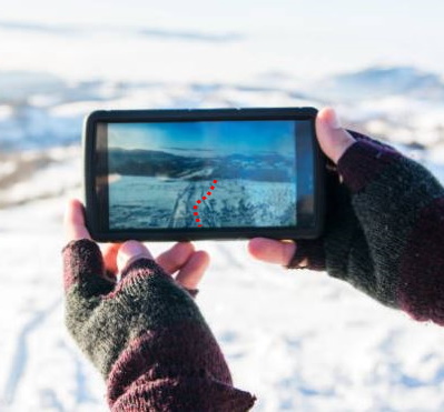
3D Maps in Ski Resorts app. 3D Wayfinder provides first person view solutions for ski resorts.

As the main land-marks on ski resorts can be modelled out in 3D, for ski lifts and tracks we can use vectors. This means that zooming out the map, will not reduce the size of the vectors. The same way you will see important roads on map applications.

For more information, please contact us.

« »

Wayfinding Advertising: Beyond the Basic

August 28, 2020

Having a wayfinding solution, for any type of establishment, is a sure way to take the visitors’ experience to a new level. Wayfinding allows people to save time and reduce stress by making navigating easy. You can get acquainted with the building and find the fastest routes. At a time of a pandemic, wayfinding also makes things safer. However there is so much more that 3D Wayfinder has to offer withour integrated solutions! For instance, let’s talk about wayfinding advertisement.

Making Full Use of Your Platform

When choosing 3D Wayfinder, you have a choice between an on-site kiosk solution, mobile application or a website integration. Or all of them! It is our view, that once you’ve chosen to have a wayfinding solution for your venue, it is silly not to apply it to it’s full potential. The two main benefits of wayfinding advertising are making the visitors’ experience more pleasant and getting a return on your investment.

Making Shopping Easier

The most obvious way to use wayfinding advertising is through banner ads displaying videos, images or animations. But we can create even more useful solutions.

For example, imagine just going shopping without a specific item to buy in your mind. You check the nearby kiosk to see what stores there are in the center. The intuitive 3D model and building directory will give you an understanding of the building, but in addition to that, the shops with an ongoing sale are highlighted. It is also possible to develop an option to search for specific items in the mall or to browse all the items on sale. You can also give high priority stores a leg up by displaying their items first.

Another clever way to notify customers is through indoor positioning and mobile apps. As the customer is moving through the venue the mobile app can send them notifications about sales in stores that they’re passing. If the app has more detailed information about the user, like age, gender or interests, it can send out even better targeted notifications.

In conclusion, there are nearly endless ways to further integrate our wayfinding and venue management solutions into your enterprise. These innovations allow you to save money and streamline your operations. In addition the upgraded customer experience will surely keep people coming back!

To find out more you can contact us here or apply for a quote here!

« »

Indoor Positioning Demo with Custom Floors and iBeacons

July 18, 2017

Now it is possible to order indoor positioning demo application. For demo we will send you required amount of iBeacons devices and create custom 2D or 3D floor plan. With 3D Wayfinder mobile application it is possible to see indoor positioning with wayfinding functionality.

iBeacons are Bluetooth low energy (BLE) devices that can broadcast their identifier to nearby portable electronic devices such as mobile phones or tablets. Also iBeacons don’t cost much and their batteries can last over year which makes them perfect for indoor positioning.

 beacon1_2

We can provide you with a custom demo map with pre-installed iBeacon locations. We will also send beacons for the demo floor plan, usually 3-6 is enough for a 1-2 room demo.  

By installing 3D Wayfinder mobile app, you can test and see iBeacon-based positioning on your real building. To order demo map with beacons, please fill the request form.

Read more about 3D Wayfinder mobile app, iBeacons and indoor positioning.

« »

3D Wayfinder Mobile Applications for Android and IOS

July 28, 2016

The development of our new 3D Wayfinder mobile applications for Android and IOS is in the final stages. It will be available in a short time. You will be able to create 3D Wayfinder applications for your venues and enable the download for people that will make it easy to find the way.

The app is based on the popular Ionic framework (Web based). Ionic is a very easy to setup and customizable mobile app framework. It uses AngularJS and Cordova. We will OpenSource the application source code so you can make Your own version.
We will also add Geolocation and iBeacon based positioning support in the near future.

« »

Node Weights in Path Calculation

August 21, 2015

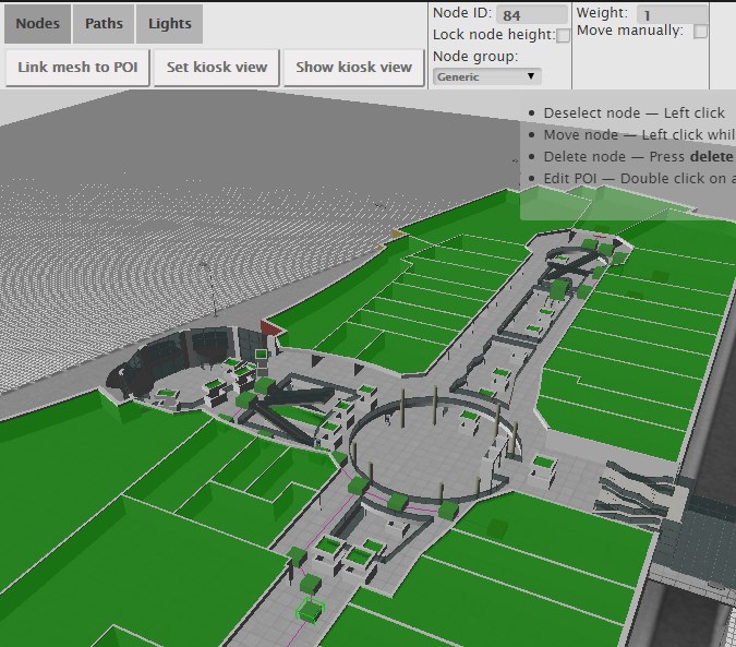
We have updated path finding functionality and path calculation. Now it is possible to change the weights of navigation nodes in 3D Wayfinder floor plan editor.

Path-finding application calculates automatically the shortest route from the starting node to the required location. In mobile applications, the Kiosk node can be your position inside the building. With 3D Wayfinder, the shortest route is calculated in a 3 dimensional room. It means the shortest path through all the floors.

Now it is possible to change the weights of the connection nodes. With this wayfinding application calculates optimal route, which doesn’t have to be the shortest. For example when you would like to guide your visitors to use the path inside the building instead of going around the building. Then you can set the weight for outdoor nodes higher. The weight is basically virtual length that will be added to the route, when passing the navigation node with a weight.

path_finding_functionality_in_3D_WayfinderTo use the weights you have to select the navigation node in 3D Wayfinder floor plan editor and change the node weight from the text box. By default all the weights are 0.

For example lets, say that waiting for the elevator takes usually 3 minutes. Lets assume, that visitors are moving with a speed of 3 km per hour, which is 50 meters per minute. So with waiting the elevator, visitor can pass 150 meters (3*50). If we would like to take account this in path calculation. Then we can add weight of 150 to the navigation node, that is marked as elevator.

Pathfinding functionality comes bundled in an add-on you can order from 3D Wayfinder Administration panel. It is also included in the Pro plan.

Read more about 3D Wayfinder’s path-finding capabilities.

« »