In the fast-paced digital era, technology continues to revolutionize the way we interact with our surroundings. One area where innovation has made significant strides is in wayfinding solutions. Gone are the days of paper maps and confusing signage. Today, we explore the synergy between wayfinding with QR codes and NFC tags. How this powerful combination is transforming navigation experiences across various industries?
Wayfinder software has emerged as a game-changer in navigation and location-based services. Leveraging GPS technology, indoor mapping, and intuitive interfaces, these applications simplify the way we navigate complex environments such as airports, malls, hospitals, and campuses. However, to truly elevate the user experience, developers have integrated additional technologies like QR codes and NFC tags.
Many of our customers have used QR codes allready for some time. Because QR-codes provide easy access to building maps without the need for information kiosks. Most people nowadays have smartphones. So with QR-code the map can be open almost with one click. Although with NFC, it is even simpler. Therefore just place your mobile phone near the NFC tag and map will be opened automatically in your cellphone browser.
Now there is option to download QR-codes for each location in 3D Wayfinder administration panel.
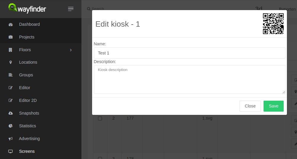
Screens module has to be enable and with each screen there is option to see the QR-code. To download QR-code, you just have to click on it. QR-code will be download in SVG format. It can be used for printing or additional designing.
QR-code takes the template that is mark as default and screen’s location. Screens can be added in 3D Wayfinder editor, by selecting any node and marking it as screen (kiosk).
QR Codes: Bridging the Physical and Digital Worlds
Quick Response (QR) codes have become ubiquitous in modern society. These two-dimensional barcodes store information that can be quickly scanned by a smartphone camera. Integrating QR codes into wayfinder software enhances the user experience by seamlessly connecting the physical environment with digital information. For instance, in a museum, visitors can scan QR codes next to exhibits to access additional information, audio guides, or interactive content, enriching their overall experience.
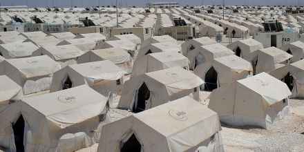
We have helped our customers to use QR-code based navigation in parking lots. So that visitors can easily get their car’s location and later on find the way back to their car. Also we have used QR-codes for exploring the corn-maze. Also in smaller shopping malls it is convenient to use printed QR-codes or QR-codes on digital displays without the need for touch-screen kiosks.
NFC Tags: A Touch of Seamless Connectivity
Near Field Communication (NFC) technology enables short-range wireless communication between devices. When integrated with wayfinder software, NFC tags provide a touch-based solution for users to access information effortlessly. Imagine a smart city scenario where commuters can tap their smartphones on NFC tags at bus stops to instantly access real-time bus schedules, route maps, and service updates. See also our solution for showing transportation schedules.
The Power of Integration
The true power of using wayfinding with QR codes and NFC tags lies in their seamless integration. By combining these technologies. Developers create a multifaceted solution that caters to diverse user preferences and accessibility needs. Whether someone prefers scanning QR codes or tapping NFC tags, the experience remains intuitive and user-friendly. With 3D Wayfinder, every code or NFC tag can be configured as different “You are here” location.
Applications Across Industries
Retail Environments: In large shopping malls, customers can scan QR codes on directories to quickly locate stores. While NFC tags on products provide detailed information and promotions. QR-codes can be use on digital signage screens or printed on walls with NFC-tags.
Healthcare Facilities
Patients and visitors can navigate hospitals efficiently by scanning QR codes on floor maps or tapping NFC tags to access appointment details and medical information. QR-codes and NFC-tags are important part in our Hopsital Wayfinder solution. That is wayfinding application specially designed for hospitals
Educational Campuses
Universities can deploy QR codes and NFC tags on campus maps. It make easier for students and visitors to find classrooms, offices, and event locations. Students are usually more opened to innovative solutions and they definitely have smartphones with them.
Transportation Hubs
Airports and train stations can optimize passenger experience by incorporating QR codes on tickets and NFC tags. For example to see real-time updates on departure gates and delays. We have made integrations for scanning boarding passes on airports. So that visitors can be automatically directed to the right gates.
Smart Cities
Municipalities can enhance public services by implementing QR codes and NFC tags on signage. Because It is important to providing citizens with instant access to information about local events, services, and emergency alerts.
In conclusion as we navigate the ever-evolving landscape of modern technology. Above all the integration of wayfinder software, QR codes and NFC tags marks a significant milestone in improving user experiences across various industries. This dynamic trio not only simplifies navigation but also opens the door to innovative applications that blend the physical and digital worlds seamlessly. The future of wayfinding is here, and it’s more connected and user-centric than ever before. All our long-time and new customers are welcome to implement our new system. Contact us and we will find the best option for you.